
Page 172 - Intro to Space Sciences Spacecraft Applications
P. 172
Satellite Navigation 159
Satellite Errors. Errors attributable to the satellite include rounding in the
ephemeris data transmitted by the satellite to the receiver, and inaccura-
cies of this reported information due to orbital parameters such as atmos-
pheric or solar pressure drag and inaccuracies of prediction of the satellite
orbit over time due to insufficient knowledge or modeling of the geopo-
tential (gravitational) model of the earth. Satellite ephemeris is computed
frequently by ground stations and the navigation message updated often
to reduce these errors. Additionally, satellite and receiver clock and oscil-
lator instabilities may introduce another, not insignificant error.
PULSE RANGING AND PHASE DIFFERENCE POSITIONING
Experience with the first Doppler-based satellite navigation systems pro-
duced newer ideas for conducting positioning from orbiting satellites, which
offered increased accuracies and eliminated some of the sources of errors
affecting the earlier method. Doppler methods compare estimated range rates
with those derived from the Doppler shift to determine a position correction.
A simpler concept involves deriving one's actual range directly from the
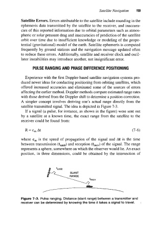
satellite transmitted signal. The idea is depicted in Figure 7-3.
If a signal (a pulse, for instance, as shown in the figure) were sent out
by a satellite at a known time, the exact range from the satellite to the
receiver could be found from:
R=c,At (7-6)
where c, is the speed of propagation of the signal and At is the time
between transmission (kmit) and reception (t,,") of the signal. The range
represents a sphere, somewhere on which the observer would lie. An exact
position, in three dimensions, could be obtained by the intersection of
Figure 7-3. Pulse ranging. Distance (slant range) between a transmitter and
receiver can be determined by knowing the time it takes a signal to travel.