
Page 176 - Intro to Space Sciences Spacecraft Applications
P. 176
Satellite Navigation 163
the case, then even if the above ranges were computed from four different
satellites, when the information was received all the times would be the
same, i.e., tl = t2 = t3 = t4. In practice, another time correction (included in
the navigation message) is incorporated to synchronize the transmitters on
board the different satellites themselves to an absolute reference time.
Errors and Accuracies
The refraction-type errors described earlier affect all types of transmis-
sions through the atmosphere and decrease the accuracy of the ranging
process as well. As with Transit, GPS satellites transmit on two different
frequencies to compensate for ionospheric effects on the signals. These
much higher frequencies (1.58 and 1.23 GHz) are also less affected by the
troposphere and additionally allow a much higher bit rate resulting in
greater accuracies.
No estimated position or track and speed information is required
because solution of the four range equations simultaneously gives a very
accurate three-dimensional fix. Satellite errors can be minimized with
more accurate and stable oscillators, better geopotential models and more
stable orbits, and updating of the navigation message more frequently.
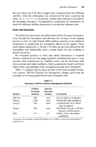
Table 7-1 compares the accuracy of some of the more common naviga-
tion systems. TACAN (Tactical Air Navigation), Omega, and Loran are
examples of existing ground-based radio navigation aids.
Table 7-1
Accuracy of Some Common Navigational Systems
~~ ~~ ~
Position Velocity
Accuracy Accuracy
System (meters) (m/sec) Comments
~~
TACAN 400 none Line of sight air navigation.
Omega 2,200 none Worldwide radio navigation.
Loran-C 180 none Localized area (U.S. shore)
radio navigation.
Transit 200 none Worldwide, but up to 100 min.
between satellite passes.
GPS 1.5" 0.1* Global, 24-hr, all-weather
availability.
*Accuracies only available to authorized (military) users. Public accuracies are appmximarely a
magnitude less.