
Page 353 - Introduction to AI Robotics
P. 353
336
9 Topological Path Planning
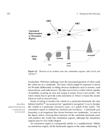
Figure 9.9 Division of an outdoor area into orientation regions, after Levitt and
Lawton. 85
localization. With that challenge went the associated question of what could
the robot use as a landmark. The land vehicle might be expected to travel
for 50 miles deliberately avoiding obvious landmarks such as houses, road
intersections, and radio towers. The idea was to have a robot vehicle capable
of stealthily scouting an area and seeing if enemy forces were nearby. The
robot vehicle has to provide some indication of where it found the enemy
forces as well as return to base.
Inside of trying to localize the vehicle to a particular landmark, the idea
QUALNAV behind QualNav 85 (an acronym for “qualitative navigation”) was to localize
ORIENTATION REGION the vehicle to a particular orientation region, or a patch of the world. The
LANDMARK PAIR orientation region is defined by landmark pair boundaries. A landmark pair
BOUNDARIES boundary is an imaginary line drawn between two landmarks. As seen in
the figure below, drawing lines between all the candidate landmark pairs
will partition the world into orientation regions, although the orientation
regions may be very oddly shaped.
An orientation region is conceptually similar to a neighborhood. Within
an orientation region, all the landmarks appear in the same relationship. If