
Page 146 - Introduction to Mineral Exploration
P. 146
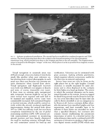
7: GEOPHYSICAL METHODS  129


                 FIG. 7.2 Airborne geophysical installation. The aircraft has been modified for combined magnetic and TEM
                 surveys. The boom projecting from above the cockpit is the forward mounting of the electromagnetic
                 transmitter loop, which extends from there to the wingtips and then to the tail assembly. The magnetometer
                 sensor is housed in the fibreglass “stinger” at the rear, which places it as far as possible from magnetic sources
                 in the aircraft.


                   Visual navigation in savannah areas was    verification. Velocities can be estimated with
                 difficult enough, since one clump of trees looks  great accuracy, making airborne gravimetry,
                 much like another when seen sideways on,     which requires velocity corrections, usable for
                 but plotting from vertical photographs in such  the first time in mineral exploration.
                 areas was often easy because tree patterns are  Survey lines must not only be flown in the
                 quite distinctive when viewed from above.    right places but at the right heights. Ground
                 Visual navigation and flight-path recovery    clearance is usually measured by radar alti-
                 were both very difficult over jungles or deserts  meter and is often displayed in the cockpits
                 and were, of course, impossible over water.  by limit lights on a head-up display. The extent
                 If there were no existing radio navigational  to which the nominal clearance can be main-
                 aids, temporary beacons might be set up, but  tained depends on the terrain. Areas too rugged
                 since several were required and each had to  for fixed-wing aircraft may be flown by helicop-
                 be manned and supplied, survey costs were    ter, but even then there may be lines that can
                 considerably increased. Self-contained Doppler  only be flown downhill or are too dangerous to
                 or inertial systems, which could be carried en-  be flown at all. Survey contracts define allow-
                 tirely within the aircraft, produced significant  able deviations from specified heights and line
                 improvements during the period from about    separations, and lines normally have to be
                 1975 to 1990, but airborne work has now been  reflown if these limits are exceeded for more
                 completely transformed by the use of global  than a specified distance, but contracts also
                 positioning satellites (GPS). GPS systems pro-  contain clauses emphasizing the paramount
                 vide unprecedented accuracy in monitoring    importance of safety. In a detailed survey the
                 aircraft position and have largely eliminated  radar altimeter data can be combined with GPS
                 the need for tracking cameras, although these  estimates of elevation to produce a high resolu-
                 are still sometimes carried for back-up and  tion digital terrain model (DTM) which may