
Page 141 - Introduction to Mineral Exploration
P. 141
124 M.K.G. WHATELEY
(a) (b)
(c) (d)
(e) (f)
(g) (h)
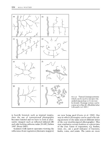
FIG. 6.12 Typical drainage patterns
which can be used to interpret the
underlying geology (a–f), see text
for details. Drainage texture can be
coarse (g) or fine (h). (Modified after
Lillesand et al. 2004.)
is heavily forested, such as tropical jungles, are now being used (Goetz et al. 1983). One
then the use of conventional photography way in which all imagery can be used is by tak-
becomes limited and we have to look at alter- ing pictures of the same area at different times
native imagery such as reflected infrared (IR) of the year (multitemporal photography). This
and side-looking airborne radar (SLAR) (Sabins may emphasize certain features at a given time
1997, Drury 2001). of the year. Lines of vegetation, e.g. bushes,
Scanners with narrow apertures viewing the trees, etc., are a good indicator of fractures,
reflectance from vegetation (thematic mappers) faults, veins, and joints. The joints are more