
Page 139 - Introduction to Mineral Exploration
P. 139
122 M.K.G. WHATELEY
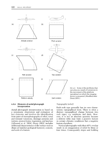
(a) (b)
Altitude variation Pitch variation
(c) (d)
Roll variation Yaw variation
(e) (f)
FIG. 6.11 Some of the problems that
can arise as a result of variations in
the movement of the platform
(aeroplane) on which the imaging
device is mounted. (Modified after
Platform velocity Earth rotation Drury 2001.)
6.4.6 Elements of aerial photograph Topography (relief)
interpretation
Each rock type generally has its own charac-
Aerial photograph interpretation is based on teristic topographical form. There is often a
a systematic observation and evaluation of distinct topographical change between two
key elements, and involves the identification rock types, e.g. sandstone and shale. How-
from pairs of stereophotographs of relief, tonal ever, it is not an absolute quantity because
and textural variations, drainage patterns and a dolerite dyke may form a positive feature
texture, erosion forms, vegetation, and land use in certain climatic conditions but a negative
(Lillesand et al. 2004). Drury (2001) includes feature elsewhere.
additional characteristics of the surface such as Vertical photographs with their 60% overlap
shape (of familiar geological features), context, result in an exaggeration of relief by three or
and scale of a feature. four times. Consequently slopes and bedding