
Page 151 - Introduction to Mineral Exploration
P. 151
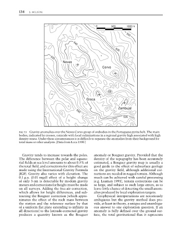
134   J. MILSOM


                                                               0         500     530
                                                                                  1000 m


                                                  540


                                     535
                                            NevesNeves                     535
                                                                   Corvo


                                                          Graca

                                                                             Zambujal
                                                    530
                                                                                535


                  FIG. 7.5 Gravity anomalies over the Neves Corvo group of orebodies in the Portuguese pyrite belt. The main
                  bodies, indicated by crosses, coincide with local culminations in a regional gravity high associated with high
                  density strata. Under these circumstances it is difficult to separate the anomalies from their background for
                  total mass or other analysis. (Data from Leca 1990.)


                    Gravity tends to increase towards the poles.  anomaly or Bouguer gravity. Provided that the
                  The difference between the polar and equato-  density of the topography has been accurately
                  rial fields at sea level amounts to about 0.5% of  estimated, a Bouguer gravity map is usually a
                  the total field, and corrections for this effect are  good guide to the effect of subsurface geology
                  made using the International Gravity Formula  on the gravity field, although additional cor-
                  (IGF). Gravity also varies with elevation. The  rections are needed in rugged terrain. Although
                  0.1 g.u. (0.01 mgal) effect of a height change  much can be achieved with careful processing
                  of only 5 cm is detectable by modern gravity  (e.g. Leaman 1991), terrain corrections can be
                  meters and corrections for height must be made  so large, and subject to such large errors, as to
                  on all surveys. Adding the free-air correction,  leave little chance of detecting the small anom-
                  which allows for height differences, and sub-  alies produced by local exploration targets.
                  tracting the Bouguer correction (which appro-  Geophysical interpretations are notoriously
                  ximates the effect of the rock mass between  ambiguous but the gravity method does pro-
                  the station and the reference surface by that  vide, at least in theory, a unique and unambigu-
                  of a uniform flat plate extending to infinity in  ous answer to one exploration question. If an
                  all directions) to the latitude-corrected gravity  anomaly is fully defined over the ground sur-
                  produces a quantity known as the Bouguer    face, the total gravitational flux it represents