
Page 312 - Introduction to Mineral Exploration
P. 312
13: SOMA LIGNITE BASIN, TURKEY 295
increased tonnage was needed to feed the town of Soma (Fig. 13.1). A high (1100 m) ridge
newly constucted 660 MW Soma B Power Sta- separates the proposed mine site from the
tion. Excess lignite would be used for domestic town. The site is on the south-facing slope of
and industrial purposes. this ridge, with elevations ranging from 750 m
The GA report deals with the geological in the north to 310 m in the south.
interpretation of the deposit, assessment of
the reserves in terms of tonnage and quality,
assessment of the geotechnical aspects of the 13.1.2 Turkish mining rights
mine area, and production of mine plans for the Mining and operating rights vary in different
proposed surface and underground mines. Most parts of the world. Before any foreign or local
of this chapter is derived from that report, al- company can start operations it is necessary to
though the geostatistical reserve estimations understand the local legal system. In Turkey all
have been subsequently completed at Leicester mineral and coal rights are deemed to be owned
University as student dissertations (Lebrun by the State and are not considered to be part of
1987, Zarraq 1987). The existing surface mine the land where they are found. The Ministry of
had suffered a major footwall failure in 1980. Energy and Natural Resources administers and
The steeply dipping, shaly, footwall sediments implements the mining laws and regulations,
underwent noncircular failure on weak hori- and grants exploration permits, exploitation
zons over several hundred meters along strike permits, and leases.
and buried the working face. One of the inten-
tions of the study was to establish the reasons
for this failure and to incorporate safety factors 13.2 EXPLORATION PROGRAMS
into the new mine design that would reduce
the risk of a repeat of this type of failure.
It is the intention in this chapter to outline 13.2.1 Previous work
the way in which the geologists who were in- The lignite in the Soma area has been mined
volved on this study collected the data, pre- since 1913, first for local domestic and indus-
sented the data for the mining and geotechnical trial consumption and later as feed for the
engineers, and calculated the reserve and qual- Soma A power station. TKI took over lignite
ity parameters. The geotechnical and mining production on 1979.
aspects are also described. To simplify this The database for this deposit was derived
chapter only the thick, lowermost seam in the from four drilling programs (Table 13.1), field
area, designated the open pit, is described. GA mapping, and a feasibility study conducted
also reported on the underground mining po- by TKI in 1981–82. The earliest study was
tential of the Soma Basin, which they reported conducted by Nebert (1978), which included
might be economically mineable in the future. lithological logs of 34 cored boreholes (Table
13.1) and two geological maps of the Soma
area with cross-sections. Cored lignite was
13.1.1 Location
analyzed for moisture and ash contents, calo-
The Soma lignite deposit is in the Manisa Prov- rific value, and in some cases volatile matter
ince of western Turkey, 10 km south of the and sulfur content. The holes were drilled at
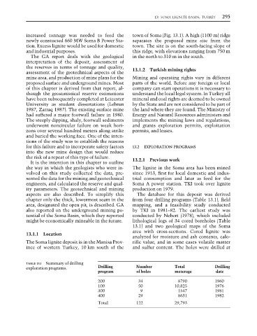
TABLE 13.1 Summary of drilling
exploration programs. Drilling Number Total Drilling
program of holes meterage date
200 34 8790 1960
100 50 10,825 1976
300 9 1547 1981
400 29 8631 1982
Total 122 29,793