
Page 308 - Introduction to Mineral Exploration
P. 308
12: CLIFFE HILL QUARRY AGGREGATE RESERVES 291
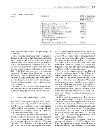
TABLE 12.1 Some major Phase 3
costs. cost center Order of magnitude
of expenditure in
1987–88 £ values
1 Exploration drilling to end of 1986 280,000
2 Sample testing to the same date 25,000
3 Geological and geophysical surveys 80,000
4 Landscape design work 75,000
5 Engineering design work and research 100,000
6 Financial and administrative 75,000
considerations
7 Compilation and submission of 20,000
planning application
Approximate total of major costs 655,000
some suitable connection, for processing at vast scales envisaged are prohibited in the UK.
Stud Farm. Such reports must be with the Inspectorate
Once planning permission had been granted, at least 30 days before the commencement of
Tarmac undertook a full financial feasibility the operations to which they relate. The quarry
study, after which further applications were development as a whole will necessitate the
submitted in 1986, both to permit an accelera- excavation of several million cubic meters of
tion of the development of the new quarry, and overburden (down to a depth of 40 m) and the
for the construction of a direct rail link from disposal of this material into natural-looking
the site to the Leicester to Burton railway line landforms on the surrounding lands.
(Fig. 12.2). Both proposals received planning The major operations constituting Phase 4
consent in the same year. Numerous controls of the development were: further drilling and
and legally binding agreements are associated testing, overburden removal, landform crea-
with the planning consents, and were formul- tion, detailed site investigation for foundation
ated in discussions between the planning au- design for the plant site (Barrett 1992), plant
thority and the company prior to the consents site excavation, quarry development, blasting,
being granted. road and rail access construction, the cultiva-
An approximate estimate of some of the ma- tion and restoration of the completed over-
jor costs for Phase 3 (as defined above) under a burden disposal areas, and the erection of the
number of headings are tabulated in Table 12.1. plants and ancillary structures. A brief sum-
mary of the Phase 4 progress on an annual basis
is as follows.
12.5 PHASE 4 – DETAILED ENGINEERING In 1986 earthworks commenced at the new
site, with the clearing of hedges, the lifting and
The Phase 3 drilling, testing, and other evalua- storage of topsoil from approximately half the
6
tion exercises having proved, to an acceptable site, and the excavation of around 1.6 × 10 m 3
risk level, the existence of an economically of overburden, mainly from the proposed plant
viable quality and quantity of material, the site at the western extremity. The excavated
major cost operations (collectively designated material was used to create a new landform
as Phase 4) commenced in 1986. on the southwestern perimeter of the site
In anticipation of the commencement of (Fig. 12.8). Two electricity powerlines were
major operations, extensive site investigation also re-routed during this period.
surveys were carried out to provide the data In 1987 earthworks continued with the
6
3
for the compilation of the statutory Mines & stripping of a further 1.6 × 10 m of overbur-
Quarries (Tips) Regulation 9 reports, without den. This operation exposed bedrock over a
which bulk excavations and depositions on the workable area and completed the excavation of