
Page 255 - Laboratory Manual in Physical Geology
P. 255
BIG IDEAS PRE-LAB VIDEO
Topographic maps are two dimensional (flat)
representations of three-dimensional landscapes, viewed
from directly above. Horizontal (two-dimensional)
positions of landscape features are represented with
symbols, colors, and lines relative to geographic grid
systems, specific scales, and directional data. The third
dimension, elevation (height) of the landscape, is
represented with contour lines marking certain elevations
in feet or meters above sea level. The three-dimensional
and quantitative aspect of topographic maps makes them
valuable to geologists and other people who want to know
the shapes and elevations of landscapes. They are often
used in combination with orthoimages (aerial photographs
that have been adjusted to the same scale as the map).
FOCUS YOUR INQUIRY
|
THINK How are specific places and quadrangles located
About It using the latitude-longitude coordinate system,
TM
Vesuvius and how could geologists use Google Earth to
study them?
ACTIVITY 9.1 Map and Google Earth Inquiry (p. 228 )
TM
|
THINK What are topographic quadrangle maps, and
About It what geographic grid systems, scales, directional
data, and symbols are represented on them?
ACTIVITY 9.2 Map Locations, Distances, Directions, and
Symbols (p. 228 )
THINK | How are topographic maps constructed and
About It interpreted?
ACTIVITY 9.3 Topographic Map Construction (p. 239 )
ACTIVITY 9.4 Topographic Map and Orthoimage
L A B O RA T O RY 9 Interpretation (p. 239 )
THINK | How are topographic maps used to calculate the
Topographic Maps About It relief and gradients (slopes) of landscapes?
ACTIVITY 9.5 Relief and Gradient (Slope) Analysis (p. 246 )
and Orthoimages THINK How is a topographic profile constructed from
|
About It a topographic map, and what is its vertical
CO NTRIB U TING A U TH O RS exaggeration?
Charles G. Higgins • University of California ACTIVITY 9.6 Topographic Profile Construction (p. 246 )
John R. Wagner • Clemson University
James R. Wilson • Weber State University
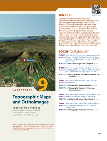
Oblique Google Earth™ view of the Italian volcano, Vesuvius, which
destroyed the Roman city of Pompeii in AD 79. Pliny the Younger
described his eyewitness account of the eruption in two letters to
Tacitus. (© Google Earth™)
227