
Page 260 - Laboratory Manual in Physical Geology
P. 260
Public Land Survey System
range boundary
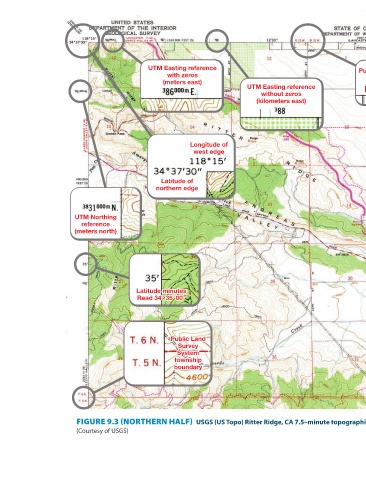
UTM Easting reference Longitude of east edge without zeros (kilometers east) Latitude of northern edge UTM Northing reference UTM Northing reference UTM Northing reference without zeros without zeros without zeros (kilometers north) (kilometers north) (kilometers north) Public Land Survey System section numbers (Northern half of map reduced to about 55% of its actual size) –minute topographic quadrangle map. USGS (US Topo) Ritter Ridge, CA 7.5
UTM Easting reference with zeros (meters east) Longitude of west edge Latitude of northern edge Latitude minutes Latitude minutes Latitude minutes Read 34° 35' 00" Read 34° 35' 00" 00 Read 34° 35 Public Land Public Land Public Land Survey Survey Survey System System System township township township boundary boundary boundary FIGURE 9.3 (NORTHERN HALF)
UTM Northing reference (meters north) (Courtesy of USGS)