
Page 265 - Laboratory Manual in Physical Geology
P. 265
READING BEARINGS WITH A PROTRACTOR READING BEARINGS WITH A COMPASS
0˚
360˚/0˚
E-W top
Read
10° 20°
bearing border of N Read
30°
E-W top 40° here map bearing
border of 50° here
map 60° 70°
80°
90˚ 270˚ W E 90˚
N N
B 100° 110° 120° 130° 140° 150° 160° 170°
D S
A B
180˚
N-S side N-S side
180˚ border of
border of
C map A map
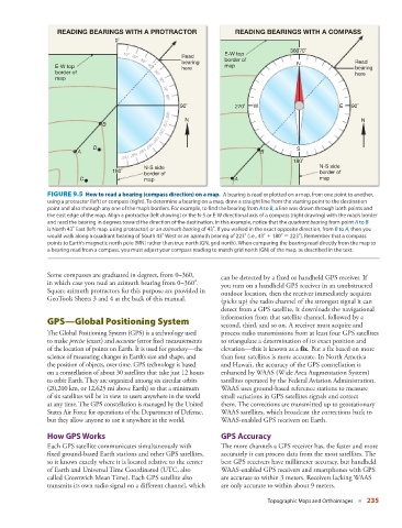
FIGURE 9.5 How to read a bearing (compass direction) on a map. A bearing is read or plotted on a map, from one point to another,
using a protractor (left) or compass (right). To determine a bearing on a map, draw a straight line from the starting point to the destination
point and also through any one of the map’s borders. For example, to find the bearing from A to B , a line was drawn through both points and
the east edge of the map. Align a protractor (left drawing) or the N-S or E-W directional axis of a compass (right drawing) with the map’s border
and read the bearing in degrees toward the direction of the destination. In this example, notice that the quadrant bearing from point A to B
is North 43° East (left map, using protractor) or an azimuth bearing of 43°. If you walked in the exact opposite direction, from B to A , then you
would walk along a quadrant bearing of South 43° West or an azimuth bearing of 223° (i.e., 43° + 180° = 223°). Remember that a compass
points to Earth’s magnetic north pole (MN) rather than true north (GN, grid north). When comparing the bearing read directly from the map to
a bearing read from a compass, you must adjust your compass reading to match grid north (GN) of the map, as described in the text.
Some compasses are graduated in degrees, from 0–360,
can be detected by a fixed or handheld GPS receiver. If
in which case you read an azimuth bearing from 0–360°.
you turn on a handheld GPS receiver in an unobstructed
Square azimuth protractors for this purpose are provided in
outdoor location, then the receiver immediately acquires
GeoTools Sheets 3 and 4 at the back of this manual.
(picks up) the radio channel of the strongest signal it can
detect from a GPS satellite. It downloads the navigational
information from that satellite channel, followed by a
GPS—Global Positioning System
second, third, and so on. A receiver must acquire and
The Global Positioning System (GPS) is a technology used process radio transmissions from at least four GPS satellites
to make precise (exact) and accurate (error free) measurements to triangulate a determination of its exact position and
of the location of points on Earth. It is used for geodesy—the elevation—this is known as a fix . But a fix based on more
science of measuring changes in Earth’s size and shape, and than four satellites is more accurate. In North America
the position of objects, over time. GPS technology is based and Hawaii, the accuracy of the GPS constellation is
on a constellation of about 30 satellites that take just 12 hours enhanced by WAAS (Wide Area Augmentation System)
to orbit Earth. They are organized among six circular orbits satellites operated by the Federal Aviation Administration.
(20,200 km, or 12,625 mi above Earth) so that a minimum WAAS uses ground-based reference stations to measure
of six satellites will be in view to users anywhere in the world small variations in GPS satellites signals and correct
at any time. The GPS constellation is managed by the United them. The corrections are transmitted up to geostationary
States Air Force for operations of the Department of Defense, WAAS satellites, which broadcast the corrections back to
but they allow anyone to use it anywhere in the world. WAAS-enabled GPS receivers on Earth.
How GPS Works GPS Accuracy
Each GPS satellite communicates simultaneously with The more channels a GPS receiver has, the faster and more
fixed ground-based Earth stations and other GPS satellites, accurately it can process data from the most satellites. The
so it knows exactly where it is located relative to the center best GPS receivers have millimeter accuracy, but handheld
of Earth and Universal Time Coordinated (UTC, also WAAS-enabled GPS receivers and smartphones with GPS
called Greenwich Mean Time). Each GPS satellite also are accurate to within 3 meters. Receivers lacking WAAS
transmits its own radio signal on a different channel, which are only accurate to within about 9 meters.
Topographic Maps and Orthoimages ■ 235