
Page 266 - Laboratory Manual in Physical Geology
P. 266
UTM—Universal Transverse Earth-centered UTM datum called the World Geodetic System
1984 or WGS84 , which is essentially the same as NAD83 .
Mercator System
However, GPS receivers can be set up to display regional
The U.S. National Imagery and Mapping Agency (NIMA) datums like NAD27 and NAD 83 . When using GPS with a
developed a global military navigation grid and coordinate topographic map that has a UTM grid, be sure to set the GPS
system in 1947 called the Universal Transverse Mercator receiver to display the UTM datum of that map. Otherwise,
System (UTM) . Unlike the latitude-longitude grid that is your locations may be incorrect by up to hundreds of meters.
TM
spherical and measured in degrees, minutes, seconds, the Google Earth uses the WGS84 UTM datum.
UTM grid is rectangular and measured in decimal-based
metric units (meters, km). Locating Points Using UTM
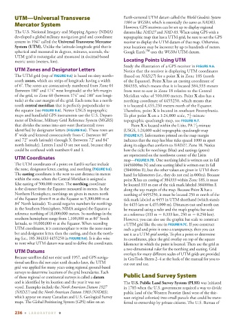
Study the illustration of a GPS receiver in FIGURE 9.6 .
UTM Zones and Designator Letters Notice that the receiver is displaying UTM coordinates
The UTM grid (top of FIGURE 9.6 ) is based on sixty north– (based on NAD27 ) for a point X in Zone 18S (north
south zones , which are strips of longitude having a width of the Equator). Point X has an easting coordinate of
of 6°. The zones are consecutively numbered from Zone 01 384333, which means that it is located 384,333 meters
(between 180° and 174° west longitude) at the left margin from west to east in Zone 18 relative to the Central
of the grid, to Zone 60 (between 174° and 180° east longi- Meridian value of 500,000 meters. Point X also has a
tude) at the east margin of the grid. Each zone has a north- northing coordinate of 4455250, which means that
south central meridian that is perfectly perpendicular to it is located 4,455,250 meters north of the Equator.
the equator (see FIGURE 9.6 ). Newer USGS topographic Therefore, point X is located in southeast Pennsylvania.
1
maps and handheld GPS instruments use the U.S. Depart- To plot point X on a 1:24,000 scale, 7 -minute
2
ment of Defense, Military Grid Reference System (MGRS) topographic quadrangle map, see FIGURE 9.7 .
1
that divides the zones into east-west (horizontal) rows Point X is located within the Lititz, PA 7 -minute
2
identified by designator letters ( FIGURE 9.6 ). These rows are (USGS, 1:24,000 scale) topographic quadrangle map
8° wide and lettered consecutively from C (between 80° ( FIGURE 9.7 ). Information printed on the map margin
and 72° south latitude) through X (between 72° and 84° indicates that the map has blue ticks spaced 1000 m apart
north latitude). Letters I and O are not used, because they along its edges that conform to NAD27 , Zone 18. Notice
could be confused with numbers 0 and 1. how the ticks for northings (blue) and eastings (green)
are represented on the northwest corner of the Lititz
UTM Coordinates
map— FIGURE 9.7B . One northing label is written out in full
The UTM coordinates of a point on Earth’s surface include (4456000m N) and one easting label is written out in full
the zone, designator letter, easting, and northing ( FIGURE 9.6 ). (384000m E), but the other values are given in UTM short-
The easting coordinate is the west-to-east distance in meters hand for kilometers (i.e., they do not end in 000m). Because
within the zone, where the Central Meridian is assigned a point X has an easting of 384333 within Zone 18S, it must
false easting of 500,000 meters. The northing coordinate be located 333 m east of the tick mark labeled 384000m E
is the distance from the Equator measured in meters. In the along the top margin of the map. Because Point X has a
Northern Hemisphere, northings are given in meters north northing of 4455250, it must be located 250 m north of the
of the Equator (from 0 m at the Equator to 9,300,000 m at tick mark labeled as 4455 in UTM shorthand (which stands
84° North latitude). To avoid negative numbers for northings for 4455 km or 4,455,000 m). Distances east and north can
in the Southern Hemisphere, NIMA assigned the Equator a be measured using a ruler and the map’s graphic bar scale
reference northing of 10,000,000 meters. So northings in the as a reference (333 m = 0.333 km, 250 m = 0.250 km).
southern hemisphere range from 1,100,000 m at 80° South However, you can also use the graphic bar scale to construct
latitude, to 10,000,000 m at the Equator. When recording a UTM grid like the one in FIGURE 9.7C . If you construct
UTM coordinates, it is commonplace to write the zone num- such a grid and print it onto a transparency, then you can
ber and designator letter, then the easting, and then the north- use it as a UTM grid overlay . To plot a point or determine
ing (i.e., 18S 384333 4455250 in FIGURE 9.6 ). It is also wise its coordinates, place the grid overlay on top of the square
to note what UTM datum was used to define the coordinates. kilometer in which the point is located. Then use the grid as
a two-dimensional ruler for the northing and easting. Grid
UTM Datums
overlays for many different scales of UTM grids are provided
Because satellites did not exist until 1957, and GPS naviga- in GeoTools Sheets 2–4 at the back of the manual for you to
tional satellites did not exist until decades later, the UTM cut out and use.
grid was applied for many years using regional ground-based
surveys to determine locations of the grid boundaries. Each
of these regional or continental surveys is called a datum Public Land Survey System
and is identified by its location and the year it was sur- The U.S. Public Land Survey System (PLSS) was initiated
veyed. Examples include the North American Datum 1927 in 1785 when the U.S. government required a way to divide
(NAD27) and the North American Datum 1983 (NAD83) , public land of the Western Frontier (land west of the thir-
which appear on many Canadian and U.S. Geological Survey teen original colonies) into small parcels that could be trans-
maps. The Global Positioning System (GPS) relies on an ferred to ownership by private citizens. The U.S. Bureau of
236 ■ L ABOR ATORY 9