
Page 267 - Laboratory Manual in Physical Geology
P. 267
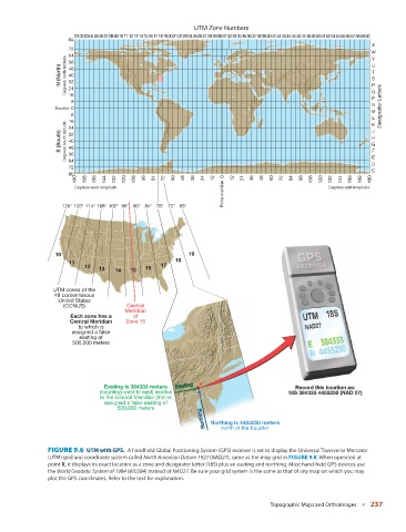
UTM Zone Numbers
                               01 02 03 04 05 06 07 08 09 10 11 12 13 14 15 16 17 18 19 20 21 22 23 24 25 26 27 28 29 30 31 32 33 34 35 36 37 38 39 40 41 42 43 44 45 46 47 48 49 50 51 52 53 54 55 56 57 58 59 60
                             84
                                                                                                                        X
                             72
                                                                                                                        W
                             64
                                                                                                                        V
                             56
                          N (North)  Degrees north latitude  48                                                         U
                                                                                                                        T
                             40
                                                                                                                        S
                             32
                                                                                                                        R
                             24
                                                                                                                        Q
                             16
                                                                                                                        P
                              8
                                                                                                                        N
                         Equator  0                                                                                        Designator Letters
                                                                                                                        M
                              8
                                                                                                                        L K
                             16
                             24
                                                                                                                        J
                          S (South)  Degrees south latitude  32                                                         H
                             40
                                                                                                                        G
                             48
                                                                                                                        F
                             56
                             64
                                                                                                                        D E
                             72
                                                                                                                        C
                             80
                               180  168  156  144  132  120  108  96  84  72  60  48  36  24  12  0  12  24  36  48  60  72  84  96  108  120  132  144  156  168  180
                                                                           Prime meridian
                               Degrees west longitude                                                      Degrees east longitude
                           126° 120° 114° 108° 102° 96° 90° 84° 78° 72° 66°
                         10                                      19
                                                             18
                             11
                                  12  13   14  15   16   17

                        UTM zones of the
                         48 conterminous
                          United States
                           (CONUS)            Central
                                              Meridian
                             Each zone has a    of
                             Central Meridian   Zone 15
                                to which is
                              assigned a false
                                easting of
                              500,000 meters


                                                             Easting
                                                             Easting
                                        Easting is 384333 meters  Easting  X                     Record this location as:
                                      (counting west to east) relative                         18S 384333 4455250 (NAD 27)
                                      to the Central Meridian (that is
                                        assigned a false easting of
                                            500,000 meters
                                                                      Northing  Northing  Northing  Northing is 4455250 meters
                                                                           north of the Equator


                         FIGURE 9.6    UTM with GPS.  A handheld Global Positioning System (GPS) receiver is set to display the Universal Transverse Mercator


                       (UTM) grid and coordinate system called  North American Datum 1927  ( NAD27 ), same as the map grid in  FIGURE   9.8   . When operated at
                       point  X , it displays its exact location as a zone and designator letter (18S) plus an easting and northing. Most hand-held GPS devices use
                       the  World Geodetic System of 1984  ( WGS84 ) instead of  NAD27 . Be sure your grid system is the same as that of any map on which you may
                       plot the GPS coordinates. Refer to the text for explanation.
                                                                                          Topographic Maps and Orthoimages   ■  237