
Page 264 - Laboratory Manual in Physical Geology
P. 264
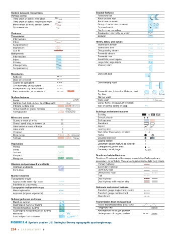
Control data and monuments                              Coastal features
                Vertical control                                           Foreshore flat                       Mud
                   Third order or better, with tablet  BM   16.3           Rock or coral reef                  Reef
                   Third order or better, recoverable mark    120.0        Rock bare or awash               *
                   Bench mark at found section corner  BM  18.6            Group of rocks bare or awash    * * * *
                                                                                                           * * * * * *
                   Spot elevation               5.3                        Exposed wreck
                                                                           Depth curve; sounding             3
                Contours                                                   Breakwater, pier, jetty, or wharf
                Topographic                                                Seawall
                   Intermediate
                   Index                                                Rivers, lakes, and canals
                   Supplementary                                           Intermittent stream
                   Depression                                              Intermittent river
                   Cut; fill                                               Disappearing stream
                Bathymetric                                                Perennial stream
                   Intermediate                                            Perennial river
                   Index                                                   Small falls; small rapids
                   Primary                                                 Large falls; large rapids
                   Index primary                                           Masonry dam
                   Supplementary

                Boundaries                                                 Dam with lock
                   National
                   State or territorial
                   County or equivalent                                    Dam carrying road
                   Civil township or equivalent
                   Incorporated city or equivalent
                   Park, reservation, or monument                          Perennial lake; Intermittent lake or pond
                                                                           Dry lake                               Dry lake
                Surface features                                           Narrow wash
                   Levee                                  Levee            Wide wash                           Wide wash
                   Sand or mud area, dunes, or shifting sand  Sand         Canal, flume, or aquaduct with lock
                   Intricate surface area                Strip mine        Well or spring; spring or seep
                   Gravel beach or glacial moraine  Gravel
                   Tailings pond                    Tailings pond       Buildings and related features
                                                                           Building
                Mines and caves                                            School; church
                   Quarry or open pit mine                                 Built-up area
                   Gravel, sand, clay, or borrow pit                       Racetrack
                 Mine tunnel or cave entrance                              Airport
                 Mine shaft                                                Landing strip
                 Prospect                                                  Well (other than water); windmill
                   Mine dump                            Mine dump          Tanks
                   Tailings                              Tailings          Covered reservoir
                                                                           Gaging station
                Vegetation                                                 Landmark object (feature as labeled)
                   Woods                                                   Campground; picnic area
                   Scrub                                                   Cemetery: small; large         Cem
                   Orchard
                   Vineyard                                             Roads and related features
                   Mangrove                         Mangrove            Roads on Provisional edition maps are not classified as primary,
                                                                        secondary, or light duty. They are all symbolized as light duty roads.
                Glaciers and permanent snowfields                          Primary highway
                   Contours and limits                                     Secondary highway
                   Form lines                                              Light duty road
                                                                           Unimproved road
                Marine shoreline                                           Trail
                Topographic maps                                           Dual highway
                   Approximate mean high water                             Dual highway with median strip
                   Indefinite or unsurveyed
                Topographic-bathymetric maps                            Railroads and related features
                   Mean high water                                         Standard gauge single track; station
                   Apparent (edge of vegetation)                           Standard gauge multiple track
                                                                           Abandoned
                Submerged areas and bogs
                   Marsh or swamp                                       Transmission lines and pipelines
                   Submerged marsh or swamp                                Power transmission line; pole; tower
                   Wooded marsh or swamp                                   Telephone line                   Telephone
                   Submerged wooded marsh or swamp                         Aboveground oil or gas pipeline
                   Rice field                        Rice                  Underground oil or gas pipeline   Pipeline
                   Land subject to inundation        Max pool 431
                 FIGURE 9.4    Symbols used on U.S. Geological Survey topographic quadrangle maps.

               234  ■  L ABOR ATORY  9