
Page 268 - Laboratory Manual in Physical Geology
P. 268
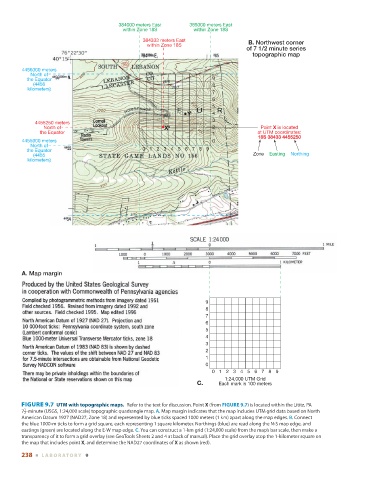
384000 meters East     385000 meters East
                                                 within Zone 18S         within Zone 18S
                                                        384333 meters East                 B. Northwest corner
                                                         within Zone 18S
                                                                                          of 7 1/2 minute series
                                                                                             topographic map


                4456000 meters
                  North of
                 the Equator                                                   9
                   (4456                                                       8
                 kilometers)
                                                                               7
                                                                               6
                                                                               5
                                                                       Y       4
                                                                               3
                    4455250 meters
                       North of                                X               2               Point X is located
                      the Equator                                              1              at UTM coordinates:
                                                                                              18S 38433 4455250
                4455000 meters                                                 0
                  North of
                 the Equator                            0123 4567 8 9
                   (4455                                                                     Zone    Easting    Northing
                 kilometers)


               A. Map margin


                                                                             9
                                                                             8
                                                                             7
                                                                             6
                                                                             5
                                                                             4
                                                                             3
                                                                             2
                                                                             1
                                                                             0
                                                                               0 123456789
                                                                                   1:24,000 UTM Grid
                                                                          C.     Each mark is 100 meters


                 FIGURE 9.7    UTM with topographic maps.          Refer to the text for discussion. Point  X  (from  FIGURE   9.7   ) is located within the Lititz, PA
                1
                  7 2  -minute (USGS, 1:24,000 scale) topographic quadrangle map.  A.  Map margin indicates that the map includes UTM grid data based on North


               American Datum 1927 (NAD27, Zone 18) and represented by blue ticks spaced 1000 meters (1 km) apart along the map edges.  B.  Connect
               the blue 1000-m ticks to form a grid square, each representing 1 square kilometer. Northings (blue) are read along the N-S map edge, and
               eastings (green) are located along the E-W map edge.  C.  You can construct a 1-km grid (1:24,000 scale) from the map’s bar scale, then make a
               transparency of it to form a grid overlay (see GeoTools Sheets 2 and 4 at back of manual). Place the grid overlay atop the 1-kilometer square on
               the map that includes point  X , and determine the NAD27 coordinates of  X  as shown (red).
               238  ■  L ABOR ATORY  9