Page 270 - Laboratory Manual in Physical Geology
P. 270

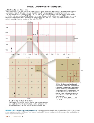
PUBLIC LAND SURVEY SYSTEM (PLSS)

               A. The Township-and-Range Grid.
               The grid is made of E-W township strips of land and N-S range strips of land (columns of land) surveyed relative to
               a principal meridian (N-S line) and its base line (E-W line). Township strips are 6 miles high and numbered T1N,
               T2N, and so on north of the base line and T1S, T2S, and so on south of the base line. Range strips (rows) of land
               are 6 miles wide and numbered R1E, R2E, and so on east of the principal meridian and R1W, R2W, and so on west
               of the principal meridian. Each intersection of a township strip of land with a range strip of land forms a square,
               called a township. Note the location of Township T1S, R2W.

                                            6 miles


               T2N

                                                         PRINCIPAL   MERIDIAN
               T1N
                                                   BASE     LINE (surveyed)

                                            Township
               T1S                                                                                      6 miles
                                           T1S, R2W

               T2S


               T3S
                       N
                       R5W     R4W    R3W    R2W     R1W    R1E     R2E    R3E    R4E     R5E    R6E

                                           6 miles                                            1 mile


                        6       5        4       3       2        1
                                                                                                             N
                                                                                       NW             NE

                        7       8        9       10      11       12
                                                       Section                                 11               1 mile

                                                                                                   NW      NE
                        18      17      16       15      14       13                                    Z
                                                                                       SW
               T 1 S
                                                                        6 miles
                                                                                                   SW      SE
                        19      20      21       22      23       24                                 X
                                                                                 C. How Sections are Subdivided.
                                                                                 Sections are subdivided according to
                                                                                 a hierarchy of square quarters listed in
                        30      29      28       27      26       25
                                                                                 order of increasing size and direction.
                                                                                 For example, point X is located in the
                                                                                 southeast quarter, of the southeast
                                                                                 quarter, of the southwest quarter, of
                        31      32      33       34      35       36             the southeast quarter, of section 11.
                           N                                                     This is written:
                                                                                 SE ¼, SE ¼, SW ¼, SE ¼, sec. 11,
                                           R 2 W
                                                                                 T1S, R2W
                    B. A Township Contains 36 Sections.
                    Each township is 6 miles wide by 6 miles long (36 square miles)
                    and subdivided into 36 sections. Each section is 1 square mile
                    (640 acres), called a section, and numbered as shown here.


                 FIGURE 9.8    U.S. Public Land Survey System (PLSS).  This survey system is based on grids of square townships, which are identified


               relative to  principal meridians  (N-S lines) of longitude and  base lines  (E-W lines, surveyed perpendicular to the principal meridian) that are
               unique to specific states or regions.
               240  ■  L ABOR ATORY  9
   265   266   267   268   269   270   271   272   273   274   275