
Page 275 - Laboratory Manual in Physical Geology
P. 275
A. PERSPECTIVE VIEW OF LANDSCAPE
100 200
266 • 200
200
BM
24 100
100
0
0
Hill
100
Saddle 100
Hill
Valley
Saddle
Saddle 200
Hill 200
100
Closed
depression
Spur at top of
Ridge
hill
Steep
slope Valley
Spur
Gentle
slope
BM
24
Ridge
266
Ridge 100
200
Overhanging
Ridge
cliff
N
Vertical
cliff 100 0
0 1 mile
Contour interval 20 ft.
0
B. TOPOGRAPHIC MAP
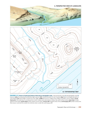
FIGURE 9.13 Names of landscape features observed on topographic maps. Note perspective view (A) and topographic map (B)
features: valley (low-lying land bordered by higher ground), hill (rounded elevation of land; mound), ridge (linear or elongate elevation or
crest of land), spur (short ridge or branch of a main ridge), saddle (low point in a ridge or line of hills; it resembles a horse saddle), closed
depression (low point/area in a landscape from which surface water cannot drain; contour lines with hachure marks), steep slope (closely
spaced contour lines), gentle slope (widely spaced contour lines), vertical cliff (merged contour lines), overhanging cliff (dashed contour line
that crosses a solid one; the dashed line indicates what is under the overhanging cliff).
Topographic Maps and Orthoimages ■ 245