
Page 274 - Laboratory Manual in Physical Geology
P. 274
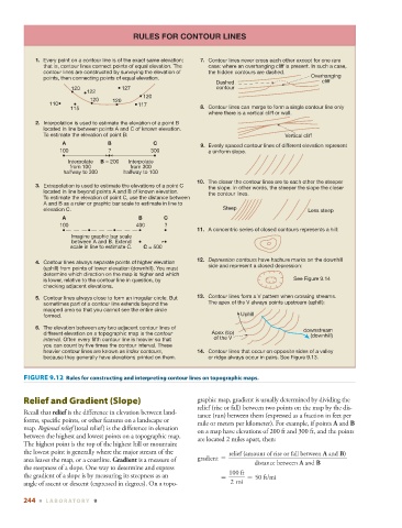
RULES FOR CONTOUR LINES


                   1. Every point on a contour line is of the exact same elevation;  7. Contour lines never cross each other except for one rare
                     that is, contour lines connect points of equal elevation. The   case: where an overhanging cliff is present. In such a case,
                     contour lines are constructed by surveying the elevation of   the hidden contours are dashed.
                     points, then connecting points of equal elevation.                                Overhanging
                                                                          Dashed                          cliff
                              120            127                          contour
                                   122
                                                    120
                                    120   120
                       110                        117
                              115                                    8. Contour lines can merge to form a single contour line only
                                                                        where there is a vertical cliff or wall.
                   2. Interpolation is used to estimate the elevation of a point B
                     located in line between points A and C of known elevation.
                     To estimate the elevation of point B:                                     Vertical cliff
                           A             B             C
                                                                     9. Evenly spaced contour lines of different elevation represent
                          100            ?            300               a uniform slope.
                             Interpolate  B = 200  Interpolate
                             from 100           from 300
                           halfway to 300     halfway to 100
                                                                    10. The closer the contour lines are to each other the steeper
                   3. Extrapolation is used to estimate the elevations of a point C  the slope. In other words, the steeper the slope the closer
                     located in line beyond points A and B of known elevation.  the contour lines.
                     To estimate the elevation of point C, use the distance between
                     A and B as a ruler or graphic bar scale to estimate in line to
                     elevation C.                                           Steep                     Less steep
                           A                      B       C
                          100                     400     ?
                                                                    11. A concentric series of closed contours represents a hill:
                              Imagine graphic bar scale
                              between A and B. Extend
                              scale in line to estimate C.  C = 500
                                                                    12. Depression contours have hachure marks on the downhill
                   4. Contour lines always separate points of higher elevation
                                                                        side and represent a closed depression:
                     (uphill) from points of lower elevation (downhill). You must
                     determine which direction on the map is higher and which
                     is lower, relative to the contour line in question, by                      See Figure 9.14
                     checking adjacent elevations.
                   5. Contour lines always close to form an irregular circle. But  13. Contour lines form a V pattern when crossing streams.
                     sometimes part of a contour line extends beyond the  The apex of the V always points upstream (uphill):
                     mapped area so that you cannot see the entire circle
                     formed.                                                     Uphill
                   6. The elevation between any two adjacent contour lines of                       downstream
                     different elevation on a topographic map is the contour  Apex (tip)               (downhill)
                     interval. Often every fifth contour line is heavier so that  of the V
                     you can count by five times the contour interval. These
                     heavier contour lines are known as index contours,  14.  Contour lines that occur on opposite sides of a valley
                     because they generally have elevations printed on them.  or ridge always occur in pairs. See Figure 9.13.


                  FIGURE 9.12    Rules for constructing and interpreting contour lines on topographic maps.


                      Relief and Gradient (Slope)                   graphic map, gradient is usually determined by dividing the
                                                                    relief (rise or fall) between two points on the map by the dis-
                 Recall that  relief  is the difference in elevation between land-
                                                                    tance (run) between them (expressed as a fraction in feet per
               forms, specific points, or other features on a  landscape or
                                                                    mile or meters per  kilometer). For  example, if points  A  and  B
               map.  Regional relief  (total relief) is the difference in elevation
                                                                    on a map have elevations of 200 ft and 300 ft, and the points
               between the highest and lowest points on a topographic map.
                                                                    are located 2 miles apart, then:
               The highest point is the top of the highest hill or mountain;
               the lowest point is generally where the major stream of the    relief (amount of rise or fall between A and B)
               area leaves the map, or a coastline.  Gradient  is a measure of      gradient =
                                                                                      distance between A and B
               the steepness of a slope. One way to determine and express
                                                                              100 ft
               the gradient of a slope is by measuring its steepness as an      =   = 50 ft/mi
               angle of ascent or descent (expressed in degrees). On a topo-  2 mi
               244  ■  L ABOR ATORY  9