
Page 257 - Laboratory Manual in Physical Geology
P. 257
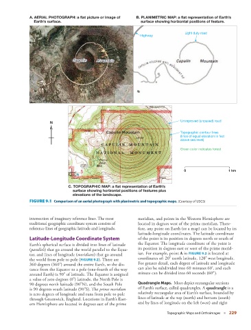
A. AERIAL PHOTOGRAPH: a flat picture or image of     B. PLANIMETRIC MAP: a flat representation of Earth’s
                        Earth’s surface.                                     surface showing horizontal positions of feature.

                                                                                                  Light duty road
                                                                            Highway


                                                                                                Unimproved (unpaved) road
                                 N
                                                                                                Topographic contour lines
                                                                                                (lines of equal elevation in feet
                                                                                                above sea level)

                                                                                                Green color indicates forest


                                                                                                  0                    1 km


                                         C. TOPOGRAPHIC MAP: a flat representation of Earth’s
                                           surface showing horizontal positions of features plus
                                           elevations of the landscape.
                         FIGURE 9.1    Comparison of an aerial photograph with planimetric and topographic maps. (Courtesy of USGS)


                         intersection of imaginary reference lines. The most   meridian, and points in the Western Hemisphere are
                         traditional geographic coordinate system consists of   located in degrees west of the prime meridian. There-
                         reference lines of geographic latitude and longitude.   fore, any point on Earth (or a map) can be located by its
                                                                           latitude-longitude coordinates. The latitude coordinate
                           Latitude-Longitude Coordinate System            of the point is its position in degrees north or south of
                         Earth’s spherical surface is divided into lines of latitude   the Equator. The longitude coordinate of the point is
                       ( parallels ) that go around the world parallel to the Equa-  its position in degrees east or west of the prime merid-
                       tor, and lines of longitude ( meridians ) that go around   ian. For example, point A in   FIGURE   9.2    is located at
                       the world from pole to pole (  FIGURE   9.2   ). There are     coordinates of: 20° north latitude, 120° west longitude.
                       360 degrees (360°) around the entire Earth, so the dis-  For greater detail, each degree of latitude and longitude
                       tance from the Equator to a pole (one-fourth of the way   can also be subdivided into 60 minutes 60′,       and each
                       around Earth) is 90° of latitude. The Equator is assigned   minute can be divided into 60 seconds (60″).
                       a value of zero degrees (0°) latitude, the North Pole is
                       90 degrees north latitude (90°N), and the South Pole       Quadrangle Maps.    Most depict rectangular sections
                       is 90 degrees south latitude (90°S). The  prime meridian    of Earth’s surface, called quadrangles. A  quadrangle  is a
                       is zero degrees of longitude and runs from pole to pole   relatively rectangular area of Earth’s surface, bounded by
                       through Greenwich, England. Locations in Earth’s East-  lines of latitude at the top (north) and bottom (south)
                       ern Hemisphere are located in degrees east of the prime   and by lines of longitude on the left (west) and right

                                                                                          Topographic Maps and Orthoimages   ■  229