
Page 311 - Laboratory Manual in Physical Geology
P. 311
A CTIVIT Y 10.7 Nevada Fault Analysis Using Orthoimages
Name: ______________________________________ Course/Section: ______________________ Date: ___________
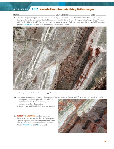
A. This orthoimage was acquired about 7 km east of Las Vegas, Nevada (US Topo: Frenchman Mtn. Quad.). The Nevada
TM
Geological Survey has determined that faulting occurred here 11–6 Ma. To view the region using Google Earth , search
36 09 34.5N, 114 56 51.6W. Use a pen to neatly and precisely trace the fault line that crosses this area and add half-arrow
symbols ( FIGURE 10.5 ) to show its relative motion. Scale: 1 cm = 0.11 km.
N
1. Exactly what kind of fault have you mapped above?
TM
B. This image was acquired just west of the one above. You can view it in Google Earth at 36 08 19.4N, 114 58 41.8W.
1. Use a pen to neatly and precisely trace all of the
faults that you can detect in the image, and add
half-arrows to show their motion.
2. Exactly what kind(s) of fault(s) have you mapped?
C. REFLECT & DISCUSS Based on your work
above, what kind of stress was this Las Vegas region
experiencing 11–6 million years ago (when the faults
formed), and why did faults form instead of folds?
Refer to FIGURES 10.1 and 10.7 as needed.
281