
Page 312 - Laboratory Manual in Physical Geology
P. 312
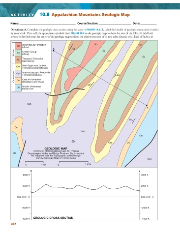
A CTIVIT Y   10.8  Appalachian Mountains Geologic Map


            Name: ______________________________________   Course/Section: ______________________   Date: ___________

        Directions: A.  Complete the geologic cross section using the steps in  FIGURE  10.6   .  B.  Label the kind(s) of geologic structure(s) revealed


        by your work. Then add the appropriate symbols from  FIGURE  10.5  to the geologic map to show the axes of the folds.  C.  Add half-


        arrows to the fault near the center of the geologic map to show the relative motions of its two sides. Exactly what kind of fault is it?
                Bloomsburg Formation                             Sb                             St
            Sb
                (shale)              X            35
           Silurian  Sc  Clinton Group                                 Sc
                (shale)
                                                                                                  Sc
                Tuscarora Formation
             St
                (sandstone)                                              Oss
                Bald Eagle and Juniata
            Oss
                Formations (sandstones)
           Ordovician  Osh  Formations (shales)                                 50
                Martinsburg and Reedsville
                Coburn Formation
            Oc
                (limestone and shale)
                                                             40
                Middle Ordovician
            Ols
                limestones


                   Osh
                                                                                                     Y


                                          St
                                                                                         70


           Oc
                                                        Osh
                                                                                                Ols

                                                                           Oss         Oc

                               GEOLOGIC MAP
                       Portions of McConnellsburg and St. Thomas
          Ols       Quadrangles, Valley and Ridge Province, South-central
                      PA. Adapted from PA Topographic and Geologic
                          Survey, Geologic Map of Pennsylvania
                                                                                                     Osh
                  0          1 km       0                  1 mile

                      X                                                                        Y
                4000 ft                                                                          4000 ft


                2000 ft                                                                          2000 ft


             Sea level   0                                                                       Sea level   0


                –2000 ft                                                                         –2000 ft


                –4000 ft  GEOLOGIC CROSS SECTION                                                 –4000 ft
        282