Page 313 - Laboratory Manual in Physical Geology
P. 313

BIG IDEAS                           PRE-LAB VIDEO

                                                                      Streams shape the landscape and provide water to
                                                                    communities and agricultural systems. Flood hazards
                                                                    and mass wasting are also associated with streams. Tools
                                                                    and methods for determining flood hazards are provided
                                                                    by the Federal Emergency Management Agency (FEMA).


                                                                     FOCUS YOUR INQUIRY
                                                                          THINK  |  How are you affected by streams?
                                                                    About It

                                                                          ACTIVITY 11.1 Streamer Inquiry  (p.  284 )
                                                                             THINK  |  How does stream erosion shape the landscape?
                                                                    About It

                                                                          ACTIVITY 11.2  Introduction to Stream Processes and
                                                                                 Landscapes   (p.  284 )

                                                                         ACTIVITY 11.3 Escarpments and Stream Terraces  (p.  284 )

                                                                         ACTIVITY 11.4  Meander Evolution on the Rio Grande
                                                                                 (p.  284 )
                                                                          ACTIVITY 11.5 Mass Wastage at Niagara Falls   (p.  292 )


                                                                           |
                                                                             THINK  How do geologists determine the risk of flooding
                                                                    About It  along rivers and streams?
                                                                          ACTIVITY 11.6  Flood Hazard Mapping, Assessment,
                                            1 11                                 and Risk   (p.  295 )


                  L A B O R A T O R Y                                       Introduction
                                                                      It all starts with a single raindrop, then another, and another.
                                                                    As water drenches the landscape, some soaks into the ground
                 Stream Processes,                                  and becomes  groundwater . Some flows over the ground and

                                                                    into streams and ponds of  surface water. The streams will
                                                                    continue to flow for as long as they receive a water supply
               Landscapes, Mass                                     from additional rain, melting snow, or  base flow
                                                                    (groundwater that seeps into a stream via porous rocks,
               Wastage, and                                         fractures, and springs).
                                                                           Perennial streams  flow continuously throughout the
                                                                    year and are represented on topographic maps as blue lines.
               Flood Hazards                                          Intermittent streams  flow only at certain times of the year,
                                                                    such as rainy seasons or when snow melts in the spring.
                                                                    They are represented on topographic maps as blue line
                        C O NTRIBUTING  A UTH O RS                  segments separated by blue dots (three blue dots between
                   Pamela J.W. Gore   •    Georgia Perimeter College  each line segment). All streams, perennial and intermittent,
                  Richard W. Macomber   • Long Island University–Brooklyn  have the potential to flood (overflow their banks). Floods
                  Cherukupalli E. Nehru   •    Brooklyn College (CUNY)  damage more human property in the United States than
                                                                    any other natural hazard.
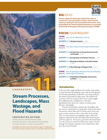
               The Middle Fork of the Salmon River flows for about 175 kilometers
               (110 miles) through a wilderness area in central Idaho. (Michael Collier)

                                                                                                                 283
   308   309   310   311   312   313   314   315   316   317   318