
Page 315 - Laboratory Manual in Physical Geology
P. 315
Heads of
Main stream tributaries B. CHANNEL TYPES IN MAP VIEW
Uplands Tributaries X, Y
Braided
Sinuous
Straight
X
Y
Meandering
Boundary of
Tributary X drainage
A. STREAM Narrow-bottomed, basin (dashed line)
DRAINAGE V-shaped valley
SYSTEM
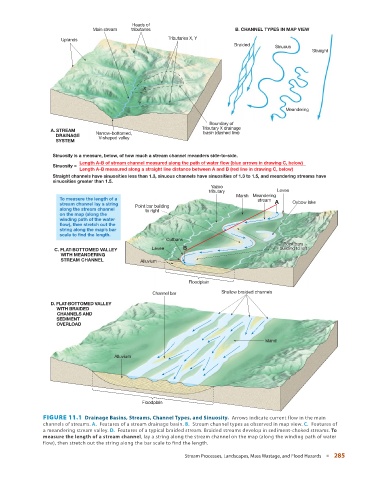
Sinuosity is a measure, below, of how much a stream channel meanders side-to-side.
Length A-B of stream channel measured along the path of water flow (blue arrows in drawing C, below)
Sinuosity =
Length A-B measured along a straight line distance between A and B (red line in drawing C, below)
Straight channels have sinuosities less than 1.3, sinuous channels have sinuosities of 1.3 to 1.5, and meandering streams have
sinuosities greater than 1.5.
Yazoo
tributary Levee
Marsh Meandering
To measure the length of a stream
stream channel lay a string Point bar building A Oxbow lake
along the stream channel to right
on the map (along the
winding path of the water
flow), then stretch out the
string along the map’s bar
scale to find the length.
Cutbank
Point bars
Point
Point bars
bars
building to left
building to left
C. FLAT-BOTTOMED VALLEY Levee B building to left
WITH MEANDERING
STREAM CHANNEL Alluvium
Floodplain
Channel bar Shallow braided channels
D. FLAT-BOTTOMED VALLEY
WITH BRAIDED
CHANNELS AND
SEDIMENT
OVERLOAD
Island
Alluvium
Floodplain
FIGURE 11.1 Drainage Basins, Streams, Channel Types, and Sinuosity. Arrows indicate current flow in the main
channels of streams. A. Features of a stream drainage basin. B. Stream channel types as observed in map view. C. Features of
a meandering stream valley. D. Features of a typical braided stream. Braided streams develop in sediment-choked streams. To
measure the length of a stream channel , lay a string along the stream channel on the map (along the winding path of water
flow), then stretch out the string along the bar scale to find the length.
Stream Processes, Landscapes, Mass Wastage, and Flood Hazards ■ 285