
Page 322 - Laboratory Manual in Physical Geology
P. 322
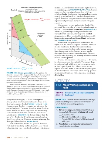
Rise or fall between two points,     channels. These channels may become highly sinuous,
                             measured vertically

             Gradient =                                      or  meandering  (see   FIGURES  11.1B   ,    11.7   ,    11.8   ). Erosion
                     Distance (run) between the two points,
                            measured horizontally            occurs on the outer edge of meanders, which are
                                                             called  cutbanks .  At the same time,  point bar  deposits

                  120                                        (mostly gravel and sand) accumulate along the inner
            A                                60 ft           edge of meanders. Progressive erosion of cutbanks and
                            Gradient from A to B =            = 40 ft/mi
                                             1.5 mi          deposition of point bars makes meanders “migrate”
                    100                                      over time.
          100
                                                                   Channels may cut new paths during floods. This
               60 ft                                         can cut off the outer edge of a meander, abandoning it to
           80          80                                    become a crescent-shaped  oxbow lake  (see   FIGURE   11.1C   ).
                                                             When low gradient/high discharge streams become
          Elevation in feet (ft)  60  1.5 mi  B  60  lines   stream  patterns. These consist of braided channels with
                                         Topographic
                                                             overloaded with sediment, they may form  braided
                                           contour
                                                             linear, underwater sandbars ( channel bars ) and islands
                                                             (see   FIGURES  11.1B    and    11.1D   ).

                                                                   Some stream valleys have level surfaces that are
           40
                                  40                         higher than the present floodplain. These are remnants
                                                             of older floodplains that have been dissected (cut
                       40 ft
           20                                                by younger streams) and are called  stream terraces  .
                                                             Sometimes several levels of stream terraces may be
                        3mi
                                                             developed along a stream, resembling steps. The steep
            0                              20                slopes or cliffs separating the relatively horizontal stream
             0
                                     C                       terraces are  escarpments .
                   1
                        2                                          Where a stream enters a lake, ocean, or dry basin,
                              3                              its velocity decreases dramatically. The stream drops
                                   4               0         its sediment load, which accumulates as a triangular
                                         5                   or fan-shaped deposit. In a lake or ocean, such a
                      Distance in miles (mi)
                          40 ft               6
        Gradient from B to C =            = 13 ft/mi         deposit is called a  delta .  A similar fan-shaped deposit

                         3.0 mi
                                                             of stream sediment also occurs where a steep-gradient
          FIGURE 11.6    Stream gradient (slope).          The gradient of a   stream abruptly enters a wide, dry plain, creating an
        stream is a measure of the steepness of its slope. As above, gradient     alluvial fan  .
        is usually determined by dividing the rise or fall (vertical relief)
        between two points on the map by the distance (run) between
        them. It is usually expressed as a fraction in feet per mile (as above)    ACTIVITY
        or meters per kilometer.
              A second way to determine and express the gradient of a    11.5   Mass Wastage at Niagara
        slope is by measuring its steepness in degrees relative to horizontal.
        Thirdly, gradient can be expressed as a percentage (also called   Falls
          grade  of a slope). For example, a grade of 10% would mean a grade
        of 10 units of rise divided by (per) 100 units of distance (i.e., 10 in.         THINK |  How does stream erosion shape the
        per 100 in., 10 m per 100 m).
                                                              About It  landscape?

        along the river margins, or banks.  Floodplains          OBJECTIVE   Describe erosional and mass wastage

        develop when alluvium accumulates landward of the     processes at Niagara Falls and calculate the rate at
        river banks, during floods (  FIGURES  11.1C    and    11.1D   ).   which the falls is retreating upstream.

        However, most flooding events do not submerge the
        entire floodplain. The more abundant minor flooding     PROCEDURES
        events deposit sediment only where the water barely        1.     Before you begin , read about Mass Wastage at
        overflows the river’s banks. Over time, this creates      Niagara Falls. Also, this is  what you will need :
        natural  levees  (  FIGURE  11.1C ) that are higher than the      ___ ruler, calculator


        rest of the floodplain. If a tributary cannot breach a        ___ 30-cm (12-inch) length of string
        river’s levee, then it will become a  yazoo tributary  that       ___ Activity 11.5 Worksheet (p.  306 ) and pencil
        flows parallel to the river (  FIGURE  11.1C   ).            with eraser

              Still farther downstream, the gradient decreases       2.     Then follow your instructor’s directions  for
        even more as discharge and load increase. The stream      completing the worksheet.
        valleys develop very wide, flat floodplains with sinuous


        292  ■  L ABOR ATORY  11