
Page 325 - Laboratory Manual in Physical Geology
P. 325
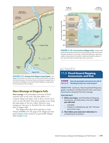
South to                          North to
                                                                           Lake Erie                       Lake Ontario
                      Queenston
                      Shale (Brown)
                                                Escarpment               0   NIAGARA RIVER
                  Whirlpool                                                                              NIAGARA
                  Sandstone                                                   Lockport                    GORGE
                                    Niagara                             50    Dolostone
                                                                      Feet below edge of Niagara Falls  150  dolostone

                                                                              Mudstone
                                                        North          100    Rochester


                                                                               sandy
                     Lockport                                          200    mudstone                    NIAGARA
                    Dolostone                                                                              RIVER
                     (Green)                                           250    Sandstone
                                                                              Whirlpool

                                                                              mudstone
                                              Niagara Gorge            300

                                                                       FIGURE 11.10    Cross Section of Niagara Falls.          Niagara Falls
                                                                     exists because the named rock units beneath the falls vary in their
                                                                     hardness (resistance to erosion). As the hard dolostone caprock is
                                                                     undercut by erosion of the softer mudstone beneath it, pieces of
                                             0    1    2 km          the caprock break off and the falls moves upstream.


                                        Goat Is.
                   Niagara
                    Falls
                                                                     ACTIVITY
                                     Niagara River
                                                                      11.6   Flood Hazard Mapping,
                  FIGURE 11.9    Geology of the Niagara Gorge Region.          The   Assessment, and Risk
                Niagara River flows from Lake Erie north to Lake Ontario and forms
                the border between the United States and Canada. Niagara Falls is         THINK |
                located on the Niagara River at the head of Niagara Gorge, about   How do geologists determine the risk of
                                                                     About It  flooding along rivers and streams?
                half way between the two lakes.
                                                                       OBJECTIVE    Construct a fl ood magnitude/frequency

                                                                     graph, map floods, and flood hazard zones, and assess

                   Mass Wastage at Niagara Falls                     flood hazards along the Flint River, Georgia.

                  Mass wastage  is the downslope movement of Earth
                                                                       PROCEDURES
               materials such as soil, rock, and other debris. It is
                                                                          1.     Before you begin , read Flood Hazard Mapping,
               common along steep slopes, such as those created where
                                                                         Assessment, and Risks below. Also, this is  what
               rivers cut into the land. Some mass wastage occurs along
                                                                         you will need :
               the steep slopes of the river valleys. However, mass
               wastage can also occur in the bed of the river itself, as it      ___ calculator
               does at Niagara Falls.                                        ___ Activity 11.6 Worksheets (pp.  307–310 ) and
                     The Niagara River flows from Lake Erie to Lake         pencil with eraser

               Ontario (  FIGURE  11.9 ). The gorge of the Niagara presents       2.     Then follow your instructor’s directions  for


               good evidence of the erosion of a caprock falls, Niagara   completing the worksheet.
               Falls (  FIGURE  11.10   ).


                                                               Stream Processes, Landscapes, Mass Wastage, and Flood Hazards   ■  295