
Page 329 - Laboratory Manual in Physical Geology
P. 329
A CTIVIT Y 11.2 Introduction to Stream Processes and Landscapes
Name: ____________________________ Course/Section: _____________________________ Date: ______________
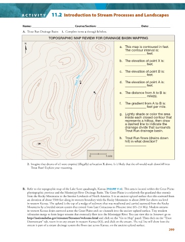
A. Trout Run Drainage Basin: 1. Complete items a through h below.
TOPOGRAPHIC MAP REVIEW FOR DRAINAGE BASIN MAPPING
N
a. This map is contoured in feet.
The contour interval is:
______________ feet.
b. The elevation of point X is:
______________ feet.
c. The elevation of point B is:
Run ______________ feet.
200 Trout B d. The elevation of point A is:
______________ feet.
A e. The distance from A to B is:
______________ mile(s).
f. The gradient from A to B is:
100 ______________ feet per mile.
200
g. Lightly shade or color the area
inside each closed contour that
represents a hilltop, then draw
a dashed line to indicate the
drainage divide that surrounds
Trout Run drainage basin.
h. Trout Run flows (drains down
hill) in what direction?
X ______________
0 1 mile
2. Imagine that drums of oil were emptied (illegally) at location X above. Is it likely that the oil would wash downhill into
Trout Run? Explain your reasoning.
B. Refer to the topographic map of the Lake Scott quadrangle, Kansas ( FIGURE 11.4 ). This area is located within the Great Plains
physiographic province and the Mississippi River Drainage Basin. The Great Plains is a relatively flat grassland that extends
from the Rocky Mountains to the Interior Lowlands of North America. It is an ancient upland surface that tilts eastward from
an elevation of about 5500 feet along its western boundary with the Rocky Mountains to about 2000 feet above sea level
in western Kansas. The upland is the top of a wedge of sediment that was weathered and carried eastward from the Rocky
Mountains by a braided stream system that existed from Late Cretaceous to Pliocene time (65–2.6 Ma). Modern streams
in western Kansas drain eastward across the Great Plains and cut channels into the ancient upland surface. Tiny modern
tributaries merge to form larger streams that eventually flow into the Mississippi River. You can view this in Streamer : go to
http://nationalatlas.gov/streamer/Streamer/welcome.html and click on the “Go to Map” panel. Then click on the “Trace
Downstream” tab, zoom in to any stream in western Kansas (KS), and click on the stream. The red line will show how the
stream is part of a stream drainage system the flows east across Kansas, on the ancient upland surface.
299