
Page 334 - Laboratory Manual in Physical Geology
P. 334
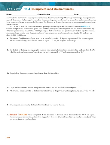
A CTIVIT Y   11.3  Escarpments and Stream Terraces


          Name: ____________________________ Course/Section: __________________________ Date: __________


            Associated with many streams are escarpments and terraces. Escarpments are long cliffs or steep narrow slopes that separate one
        relatively level part of the landscape from another. Terraces are long, narrow or broad, level surfaces bounded on one or both sides

        by an escarpment. Stream terraces parallel the stream Th e difference in elevation between two terraces can range from centimeters
        to tens of meters.
              Refer to part of the the Voltaire, North Dakota quadrangle (orthoimage with topographic contours) in  FIGURE  11.7   .

          Glaciers (composed of a mixture of ice, gravel, sand, and mud) were present in this region at the end of the Pleistocene Ice Age.
        When the glaciers melted about 11,000–12,000 years ago, a thick layer of sand and gravel was deposited on top of the bedrock,

        and streams began forming from the glacial meltwater. Therefore, streams have been eroding and shaping this landscape for
        about 11,000–12,000 years.


           A.   The modern floodplain of the Souris River can be identified by its lush, dark green vegetation and blue meandering river.

            What other meandering stream features named in  Figure  11.1C  do you recognize in this image?


           B.   On the basis of the image and topographic contours, make a sketch, below, of a cross section of the landscape from  X  to  Y .

            Label the north and south sides of your sketch, and label terraces with a “T” and escarpments with an “E.”


           C.   Describe how the escarpments may have formed along the Souris River.


           D.   On your sketch, label the modern floodplain of the Souris River and record its width along line  X–Y .


           E.   What was the maximum width of the Souris River floodplain in the past (measured along line  X–Y ) and how can you tell?


           F.   Give one possible reason why the Souris River floodplain was wider in the past.


           G.  REFLECT & DISCUSS  Notice along line  X–Y  that the terrace on the south side of the Souris River is 30–40 feet higher
            than the terrace on the north side of the river. Suggest how these two different levels of terraces may have formed and which
            one is older based on your hypothesis.


        304