
Page 337 - Laboratory Manual in Physical Geology
P. 337
A CTIVIT Y 11.6 Flood Hazard Mapping, Assessment, and Risk
Name: ____________________________ Course/Section: ___________________________ Date: __________
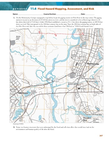
A. On the Montezuma, Georgia topographic map below, locate the gaging station on Flint River in the map center. The gaging
station is located at an elevation of 255.83 feet above sea level, and the river is considered to be at flood stage when it is 20
feet above this level (275.83 feet). A July 1994 flood established a record at 35.11 feet above the gaging station, or 289.94 feet
above sea level. This corresponds to the 290-foot contour line on the map. Trace the 290-foot contour line on both sides of
the Flint River and label the area within these contours (land lower than 290 feet) as “1994 Flood Hazard Zone.”
X
Y
Z
Mobile
home
park
Bethel
Bethel
Bethel
Church
Chur ch
Church
School
School
School
Felton
Felton
Felton
Cemetery
Cemetery
Cemetery
Gaging
Gaging
Gaging Montezuma Post Office
Montezuma Post Office
Montezuma Post Office
station
station
station
Georgia Power Co
Georgia Power Co
Georgia Power Co
Drinking
Drinking water
Drinking water
water
plant
filtration plant
filtration
filtration plant
Hospital
Hospital
Hospital
Sewage
Sewage
Sewage
tr treatment
eatment
treatment
pond
pond
pond
(Courtesy of USGS)
B. Name two human structures that were submerged by the flood and tell what effect that would have had on the
environment and human quality of life after the flood.
307