
Page 340 - Laboratory Manual in Physical Geology
P. 340
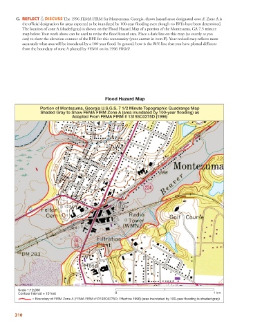
G.  REFLECT & DISCUSS The 1996 FEMA FIRM for Montezuma, Georgia, shows hazard areas designated zone A. Zone A is
            the official designation for areas expected to be inundated by 100-year flooding even though no BFEs have been determined.
            The location of zone A (shaded gray) is shown on the Flood Hazard Map of a portion of the Montezuma, GA 7.5 minute
            map below. Your work above can be used to revise the flood hazard area. Place a dark line on this map (as exactly as you
            can) to show the elevation contour of the BFE for this community (your answer in item F). Your revised map reflects more
            accurately what area will be inundated by a 100-year flood. In general, how is the BFE line that you have plotted different
            from the boundary of zone A plotted by FEMA on its 1996 FIRM?


                                                    Flood Hazard Map

                    Portion of Montezuma, Georgia U.S.G.S. 7 1/2 Minute Topographic Quadrange Map
                     Shaded Gray to Show FEMA FIRM Zone A (area inundated by 100-year flooding) as
                                    Adapted From FEMA FIRM # 13193C0275D (1996)


          Scale 1:12,000
          Contour Interval = 10 feet                     0                                              1 km
                 = Boundary of FIRM Zone A (FEMA FIRM #13193C0275D; Effective 1996) (area inundated by 100-year flooding is shaded gray)


        310