
Page 330 - Laboratory Manual in Physical Geology
P. 330
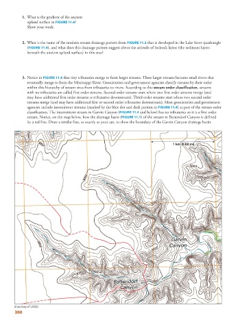
1.   What is the gradient of the ancient

              upland surface in  FIGURE  11.4   ?

              Show your work.


               2.   What is the name of the modern stream drainage pattern from   FIGURE  11.2  that is developed in the Lake Scott quadrangle


              (  FIGURE  11.4 ), and what does this drainage pattern suggest about the attitude of bedrock layers (the sediment layers

              beneath the ancient upland surface) in this area?

               3.    Notice in  FIGURE  11.4  that tiny tributaries merge to form larger streams. These larger streams become small rivers that


              eventually merge to form the Mississippi River. Geoscientists and government agencies classify streams by their order
              within this hierarchy of stream sizes from tributaries to rivers. According to this  stream order classification  ,  streams
              with no tributaries are called first order streams. Second order streams start where two first order streams merge (and
              may have additional first order streams as tributaries downstream). Third order streams start where two second order
              streams merge (and may have additional first or second order tributaries downstream). Most geoscientists and government


              agencies include intermittent streams (marked by the blue dot and dash pattern in  FIGURE  11.4 ) as part of the stream order


              classification. The intermittent stream in Garvin Canyon ( FIGURE  11.4  and below) has no tributaries so it is a first order


              stream. Notice, on the map below, how the drainage basin (  FIGURE  11.1 ) of the stream in Battendorf Canyon is defined


              by a red line. Draw a similar line, as exactly as youi can, to show the boundary of the Garvin Canyon drainage basin.
                                                                                          0.62
                                                                                         (
                                                                                       m
                                                                                     1 km (0.62 mi)mi)
                                                                                     1 1 km (0.62 mi)
                                                                                       k


        (Courtesy of USGS)
        300