
Page 365 - Laboratory Manual in Physical Geology
P. 365
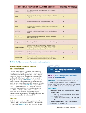
MOUNTAIN    CONTINENTAL
                           EROSIONAL FEATURES OF GLACIATED REGIONS
                                                                                      GLACIATION   GLACIATION
                                       Bowl-shaped depression on a high mountain slope, formed by a
                       Cirque                                                              X
                                       cirque glacier

                                        Sharp, jagged, knife-edge ridge between two cirques or glaciated
                       Arête                                                               X
                                        valleys

                       Col             Mountain pass formed by the headward erosion of cirques  X


                                       Steep-sided, pyramid-shaped peak produced by headward erosion
                       Horn                                                                X
                                       of several cirques
                                       Steep slope or rock cliff at the upslope end of a glaciated valley or
                       Headwall                                                            X
                                       cirque

                                       U-shaped, steep-walled, glaciated valley formed by the scouring
                       Glacial trough                                                      X
                                       action of a valley glacier

                       Hanging valley  Glacial trough of a tributary glacier, elevated above the main trough  X

                                       Asymmetrical knoll or small hill of bedrock, formed by glacial
                                       abrasion on the smooth stoss side (side from which the glacier
                       Roche moutonnée                                                                  X
                                       came) and by plucking (prying and pulling by glacial ice) on the
                                       less-smooth lee side (down-glacier side)
                       Glacial striations  Parallel linear scratches and grooves in bedrock surfaces, resulting  X  X
                       and grooves     from glacial scouring

                                       Smooth bedrock surfaces caused by glacial abrasion (sanding
                       Glacial polish                                                      X            X
                                       action of glaciers analogous to sanding of wood with sandpaper)

                 FIGURE 13.5    Erosional features of mountain or continental glaciation.

                   Nisqually Glacier—A Global                       ACTIVITY
               Thermometer?                                          13.6   The Changing Extent of

                 Nisqually Glacier is one of many active valley glaciers that   Sea Ice
               occupy the radial drainage of Mt. Rainier—an active volcano
                                                                              |
               located near Seattle, Washington, in the Cascade Range of
                                                                     THINK  How is the cryosphere affected by
               the western United States. Nisqually Glacier occurs on the
                                                                     About It  climate change?
               southern side of Mt. Rainier and flows south toward the
               Nisqually River Bridge in   FIGURE   13.15   . The position of the
                                                                     OBJECTIVE  Measure how the extent of sea ice has
               glacier’s terminus (downhill end) was first recorded in 1840,
                                                                     changed annually in the past, predict how it may
               and it has been measured and mapped by numerous geologists

                                                                     change in the future, and infer what benefits or hazards

               since that time. The map in   FIGURE  13.15    was prepared by

                                                                     could result if Arctic sea ice continues to decline.
               the U.S. Geological  Survey in 1976 and shows where the
               terminus of Nisqually  Glacier was located at various times   PROCEDURES
               from 1840 to 1997. (The 1994, 1997, and 2010 positions
                                                                       1.  Before you begin, read Sea Ice. Also, this is what
               were added for this laboratory, based on NHAP aerial
                                                                         you will need:
               photographs and satellite imagery.) Notice how the glacier has
                                                                         ____ 30 cm (12 in.) length of thread or thin string
               more or less retreated up the valley since 1840.
                                                                         ____ ruler, calculator
                   Sea Ice                                               ____  Activity 13.7 Worksheets (pp. 355–356) and
                                                                             pencil
                 Sea ice is frozen ocean water. The largest masses of sea
                                                                       2.  Then follow your instructor’s directions for
               ice occur in the Arctic Ocean and around the continent
                                                                         completing the worksheets.

               of Antarctica (  FIGURE  13.16 ). In both locations, the sea


                                                                                  Glaciers and the Dynamic Cryosphere   ■  335