
Page 363 - Laboratory Manual in Physical Geology
P. 363
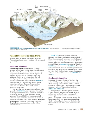
Cirque  Lateral moraine
                                                  glacier
                                                                      Horn
                         Bergschrund   Snowline       Medial    Arête      Cirque
                                                     moraines
                                                                          glaciers
                    Snowfield


                                        Transverse
                                         crevasses
                   ZONE OF
                                                         Valley
                ACCUMULATION
                                                         glacier

                                                                 Longitudinal
                         Snowline   ZONE OF
                                                                  crevasses
                                   ABLATION

                                                               Ground moraine


                 FIGURE 13.3    Active mountain glaciation, in a hypothetical region.  Note the cutaway view of glacial ice, showing flow lines and


               direction (blue lines and arrows).


                   Glacial Processes and Landforms                         FIGURE  13.3  shows the results of mountain

                                                                      glaciation after the glaciers have completely melted.
                 Glaciated lands are affected by either local to regional   Notice the  characteristic landforms, water bodies, and
               “mountain glaciation” or more continent-wide “ continental   sedimentary deposits. For your convenience, distinctive
               glaciation.”
                                                                    features of  glacial lands are summarized in three figures:
                                                                      erosional features  in   FIGURE  13.4   ,  depositional features  in


                   Mountain Glaciation                                FIGURE  13.5   , and  water bodies  in  FIGURE  13.6   . Note that
                                                                    some  features are identical in mountain glaciation and
                  Mountain glaciation  is characterized by cirque   continental  glaciation, but  others are unique to one or
               glaciers, valley glaciers, piedmont glaciers, and ice caps.   the other. Study the descriptions in these three figures
               Poorly developed mountain glaciation involves only   and compare them with the visuals in   FIGURES  13.2
               cirques, but the best-developed mountain glaciation   and     13.3   .
               involves all three types. In some cases, valley and
               piedmont glaciers are so well developed that only        Continental Glaciation
               the highest peaks and ridges extend above the ice.
               Ice caps cover even the peaks and ridges.   FIGURE   13.2        During the Pleistocene Epoch, or “Ice Age,” that
               shows a region with mountain  glaciation. Note the   ended 11,700 years ago, thick ice sheets covered most
               extensive  snowfield  in the zone of  accumulation.   of Canada, large parts of Alaska, and the northern
                 Snowline  is the elevation above which there is    contiguous United States. These continental glaciers
               permanent snow cover.                                produced a variety of characteristic landforms

                     Also note that there are many cracks or fissures in the   (  FIGURE   13.7   ,  FIGURE  13.8   ).
               glacial ice of   FIGURE  13.2 . At the upper end of the glacier         Recognizing and interpreting these landforms


               is the large  bergschrund  (German, “mountain crack”) that   is  important in conducting work such as regional
               separates the flowing ice from the relatively immobile   soil  analyses, studies of surface drainage and
               portion of the snowfield. The other cracks are called   water  supply, and exploration for sources of sand,
                  crevasses —open fissures that form when the velocity of   gravel, and  minerals. The thousands of lakes in the
               ice flow is variable (such as at bends in valleys).   Transverse     Precambrian Shield area of Canada also are a legacy
               crevasses  are perpendicular to the flow direction, and   of this  continental glaciation, as are the fertile soils
                  longitudinal crevasses  are aligned parallel with the   of the north-central United States and south-central
                 direction of flow.                                 Canada.


                                                                                  Glaciers and the Dynamic Cryosphere   ■  333