
Page 361 - Laboratory Manual in Physical Geology
P. 361
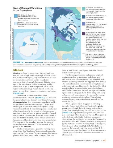
Map of Regional Variations                                                     SEASONAL SNOW: Snow
               in the Cryosphere                                                              and ice may accumulate here
                                                                                              in winter, but it melts over the
                                                                                              following summer.
                     ICE SHELF: A sheet of ice                                                PERMAFROST CONTINUOUS:
                     attached to the land on one                                              The ground is permanently
                     side but afloat on the ocean on                                          frozen over this entire area.
                     the other side.
                     SEA ICE: A sheet of ice that                       • North Pole          PERMAFROST
                     originates from the freezing of                                          DISCONTINUOUS: The ground
                     seawater.                                                                is permanently frozen in
                                                                                              isolated patches within this
               no/graphicslib/detail/the-cryosphere-world-map_e290.) (Courtesy of The Cryoshphere, world map, UNEP/GRID-Arendal, www.grida.  • South Pole  mountain sides (cirques),
                                                                                              area.
                                                                                              MOUNTAIN GLACIERS AND
                                                                                              ICE CAPS: This area contains
                                                                                              permanent patches of ice on
                                                                                              river-like bodies of ice that flow
                                                                                              down and away from
                                                                                              mountains (valley and
                                                                                              piedmont glaciers), and
                                                                                              dome-shaped masses of ice
                                                                                              and snow that cover the
                                                                                              summits of mountains so that
                                                                                              no peaks emerge (ice cap).
                                                                                              ICE SHEET: A pancake-like
                                                                                              mound of ice covering a large
                                                                                              part of a continent (more than
                                                                                                     2
                                                                                              50,000 km ).


                 FIGURE 13.1    Cryosphere components.  You can also download a complete world map of cryosphere components from this UNEP


               (United Nations Environment Programme) website:     http://www.grida.no/graphicslib/detail/the-cryosphere-world-map_e290
                   Glaciers                                         (tons of rock debris), and deposit their load “down-
                  Glaciers  are large ice masses that form on land areas   stream”  (down-glacier).
               that are cold enough and have enough snowfall to sus-      The downslope movement and extreme weight of
               tain them year after year. They form wherever the win-  glaciers cause them to abrade and erode (wear away)
               ter accumulation of snow and ice exceeds the         rock materials that they encounter. They also  pluck  rock
               summer ablation (also called  wastage ).  Ablation  (wast-  material by freezing around it and ripping it from bedrock.
               age) is the loss of snow and ice by melting and by   The rock debris is then incorporated into the glacial ice
                 sublimation  to gas (direct change from ice to water   and transported many kilometers by the glacier. The debris
               vapor, without melting). Accumulation commonly       also gives glacial ice extra abrasive power. As the heavy
               occurs in  snowfields —regions of permanent snow cover   rock-filled ice moves over the land, it scrapes surfaces like
                (  FIGURE   13.2   ).                               a giant sheet of sandpaper. Rock debris falling from valley
                     Glaciers can be divided into two zones,        walls commonly accumulates on the surface of a moving
               accumulation and ablation (  FIGURE  13.2   ). As snow and   glacier and is transported downslope. Thus, glaciers

               ice accumulate in and beneath snowfields of the  zone   transport huge quantities of sediment, not only  in,  but
               of accumulation  ,  they become compacted and highly   also  on  the ice.
               recrystallized under their own weight. The ice mass        When a glacier melts, it appears to retreat up
               then begins to slide and flow downslope like a very   the valley from which it flowed. This is called  glacial
               viscous (thick) fluid. If you  slowly  squeeze a small piece   retreat  ,  even though the ice is simply melting back
               of ice in the jaws of a vise or pair of pliers, then you   (rather than moving back up the hill). As melting occurs


               can observe how it flows. In nature, glacial ice formed   (  FIGURE  13.3 ), deposits of rocky gravel, sand, silt, and
               in the zone of accumulation flows and slides downhill   clay accumulate where there once was ice. These deposits
               into the  zone of ablation  ,  where it melts or sublimes   collectively are called  drift  .  Drift that accumulates
               (undergoes sublimation) faster than new ice can form.   directly from the melting ice is unstratified (unsorted by
               The  snowline  is the boundary between the zones of   size) and is called  till  .  However, drift that is transported
               accumulation and ablation. The bottom end of the     by the meltwater becomes more rounded, sorted by size,

               glacier is the  terminus  .                          layered, and is called  stratified drift  . Wind also can
                     It helps to understand a glacier by viewing it as a   transport the sand, silt, and clay particles from drift.
               river of ice. The “headwater” is the zone of accumula-  This wind-transported sediment can form dunes or  loess
               tion, and the “river mouth” is the terminus. Like a river,   deposits (wind-deposited, unstratified accumulations
               glaciers  erode  (wear away) rocks, transport their load   of clayey silt).


                                                                                  Glaciers and the Dynamic Cryosphere   ■  331