
Page 381 - Laboratory Manual in Physical Geology
P. 381
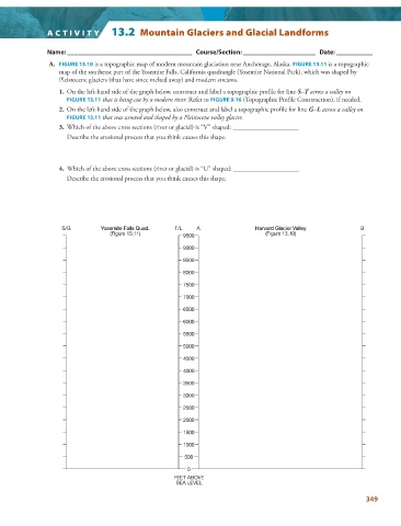
ACTIVITY   13.2  Mountain Glaciers and Glacial Landforms


                 Name: ______________________________________   Course/Section: ______________________   Date: ___________


                  A.  FIGURE  13.10  is a topographic map of modern mountain glaciation near Anchorage, Alaska.  FIGURE  13.11    is a topographic


                   map of the southeast part of the Yosemite Falls, California quadrangle (Yosemite National Park), which was shaped by
                   Pleistocene glaciers (that have since melted away) and modern streams.

                   1.   On the left-hand side of the graph below, construct and label a topographic profile for line  S–T across a valley on
                     FIGURE   13.11 that is being cut by a modern river. Refer to  FIGURE  9.16  (Topographic Profile Construction), if needed.


                   2.   On the left-hand side of the graph below, also construct and label a topographic profile for line  G–L across a valley on

                     FIGURE  13.11 that was scoured and shaped by a Pleistocene valley glacier.


                   3.   Which of the above cross sections (river or glacial) is “V” shaped: ____________________
                       Describe the erosional process that you think causes this shape.
                   4.   Which of the above cross sections (river or glacial) is “U” shaped: ____________________

                       Describe the erosional process that you think causes this shape.


                    S/G         Yosemite Falls Quad.  T/L    A                 Harvard Glacier Valley          B
                                   (Figure 13.11)        9500                     (Figure 13.10)

                                                         9000
                                                         8500
                                                         8000

                                                         7500
                                                         7000
                                                         6500

                                                         6000
                                                         5500
                                                         5000

                                                         4500
                                                         4000

                                                         3500
                                                         3000
                                                         2500
                                                         2000

                                                         1500
                                                         1000

                                                         500
                                                          0
                                                      FEET ABOVE
                                                       SEA LEVEL

                                                                                                                 349