
Page 397 - Laboratory Manual in Physical Geology
P. 397
ACTIVITY raises the level of the lake. Therefore, the level of Great
Salt Lake has varied significantly in historic times over
14.4 Dryland Lakes of Utah periods of months, years, and decades. During one dry
period of many years, people ignored the dryland hazard
of fluctuating lake levels and constructed homes, roads,
THINK How can topographic maps and aerial farms, and even a 2.5-million-dollar resort, the Saltair, near
About It photographs of drylands be used to the shores of Great Salt Lake. When a wet period occurred
interpret how their environments have from 1982–87, many of these structures (including the
changed?
resort) were submerged. The State of Utah installed huge
pumps in 1987 to pump lake water into another valley, but
OBJECTIVE Analyze a stereogram and topographic the pumps were left high and dry during a brief dry period
map of the Utah desert to evaluate the history of Lake that lasted for 2 years (1988–89) after they were installed.
Bonneville.
Geologic studies now suggest that the historic fluctuations
PROCEDURES of Great Salt Lake are minor in comparison to those that have
1. Before you begin , read Dryland Lakes below. Also, occurred over millennia. Great Salt Lake is actually all that
this is what you will need : remains of a much larger lake that covered 20,000 square
miles of Utah—Lake Bonneville. Lake Bonneville reached its
____ colored pencils maximum depth and geographic extent about 17,000 years
____ Activity 14.4 Worksheet (p. 373 ) and pencil
2. Then follow your instructor’s directions for ago as glaciers were melting near the end of the last Ice Age.
One arm of the lake at that time extended into Wah Wah
completing the worksheets.
Valley, Utah, which is now a dryland ( FIGURE 14.8 ).
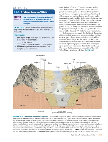
Mountain front
Piedmont Fault
slope
Inselberg Piedmont slope
Bajada Alluvial fans
Playa
Sand
dunes
Salt
flat
HORST
HORST
Mud
Silt
Salts
Alluvium
Bedrock
GRABEN
Pediment Normal faults
(arrows indicate relative motions)
FIGURE 14.7 Landforms of mountainous drylands. These landforms are typical of arid mountainous deserts in regions of the southewestern
United States, where Earth’s crust has been lengthened by tensional forces (pulled apart). Mountain ranges and basins develop by block faulting —a
type of regional rock deformation where Earth’s crust is broken into fault-bounded blocks of different elevations. The higher blocks form mountains
called horsts and the lower blocks form valleys called grabens . Note that the boundaries between horsts and grabens are typically normal faults.
Sediment eroded from the horsts is transported into the grabens by wind and water. Alluvial fans develop from the mountain fronts to the valley floors.
They may surround outlying portions of the mountain fronts to create inselbergs (island-mountains). The fans may also coalesce to form a bajada.
In cases where there is no drainage outlet from the valley, the valley is a closed basin from which water can escape only by evaporation. Because rain is
infrequent in drylands, the lakes that form are temporary ( playas ). When they evaporate, all that is left is a salt flat (a patch of level land that is encrusted
with salt.). Wind blowing over the valleys can form sand dunes made of salt crystals or muineral grains eroded from bedrock (usually quartz sand).
Dryland Landforms, Hazards, and Risks ■ 365