
Page 393 - Laboratory Manual in Physical Geology
P. 393
0 1 2 3 miles
0 1 2 3 4 km
Amargosa
Amargosa
Amargosa
Mountains
Mountains
Mountains
Outline of map
in Activity 14.2
Furnace
Creek
Panamint
Panamint
Panamint
Mountains
Mountains
Mountains
Amargosa
Amargosa
Amargosa
Mountains
Mountains
Mountains
Panamint
Panamint
Panamint
Mountains
Mountains
Mountains
Badwater
Basin
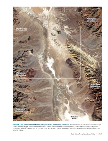
FIGURE 14.3 Overhead satellite view of Mojave Desert, Death Valley, California. Notice Badwater Basin at the bottom of the image.
The water is very alkaline there, when present. Furnace Creek is the only location in the valley with potable water and significant vegetation.
TM
View in Google Earth by searching: 36 22 N, 116 53 W. (NASA Earth Observatory image processed by Jesse Allen and Robert Simmon using
NASA EO-1 data.)
Dryland Landforms, Hazards, and Risks ■ 361