
Page 391 - Laboratory Manual in Physical Geology
P. 391
To Yuma, AZ (10 mi)
To view in Google Earth™, search:
32 44 N, 114 54 W
All-American Canal (water from Colorado River)
All-American Canal (water from Colorado River)
All-American Canal (water from Colorado River)
Interstate
Interstate
Interstate
Route 8
Route 8
Route 8
Algodones dunes
(Courtesy Bureau of Land Management, Bob Wick)
All-American
All-American
All-American
Canal
Canal
Canal
California, USA
Interstate
Interstate
Interstate
Route 8 Mexico
Route
8
Route 8
Coachella Canal North
Coachella Canal
Coachella Canal
Water to 0 1 mile
northern
Imperial 0 1 kilometer
Valley
Water to Imperial Valley, California
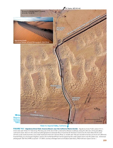
FIGURE 14.1 Algodones Dune Field, Sonoran Desert, near the California-Mexico border. Algodones Dune Field is about 10 km
(6 mi) wide and 70 km (45 miles long). The long axis of the dune field is oriented northwest-southeast, along the direction of the prevailing
northwest winds. Notice in this astronaut photograph how Interstate Route 8 and the All-American Canal cross the dune field. The 85-mile
(53-km) canal and its branches carry water westward, from the Colorado River (at 26,000 cubic feet per second) to homes and farms of California’s
Imperial Valley. It is the largest irrigation canal in the world. Runoff from land irrigated by the canal system drains into the Salton Sea. (Astronaut
photograph ISS018-E-24949, acquired 1-31-2009, courtsey of Image Science & Analysis Laboratory, NASA Johnson Space Center. )
359