
Page 395 - Laboratory Manual in Physical Geology
P. 395
of infrequent rain storms and flash floods that erode the
landscape and transport and deposit sediment. However,
these effects are enhanced in tectonically active regions,
where there is greater relief of the land.
When it rains in mountainous drylands, the water
Sand Hills simply runs off of the rocks because there is no soil to
absorb it. This leads to development of severe flash floods,
which have the cutting power to erode rock and transport
sediment. These flash floods often develop into mudflows
NEBRASKA
(sediment liquified with water, and having the consistency
KANSAS and density of concrete being poured from a “cement mixer”
truck). Flash floods and mudflows do millions of dollars
worth of damage to human properties each year and claim
many lives. They also lead to development of alluvial fans
(fan-shaped, delta-like deposits of sediment that develop
where the flash floods and mudflows empty into a valley).
The southwestern United States (Great Basin) is one of
many arid regions of the world where Earth’s crust is being
lengthened by tensional forces (pulled apart). This leads to
block faulting —a type of regional rock deformation where
Earth’s crust is broken into fault-bounded blocks of different
elevations. The higher blocks are called horsts and the lower
blocks are grabens (see FIGURE 14.7 ). Steep slopes develop
0 100 200 300 mi
Sand along faults, between the blocks. After severe thunderstorms,
0 100 200 300 km flash floods and mudflows commonly flow from the horsts
Silt (loess) into the graben valleys. Huge alluvial fans develop where the
stream valleys of the flash floods and mudflows empty into
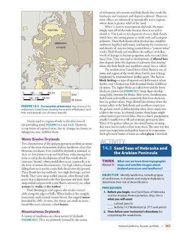
FIGURE 14.5 The Sand Hils of Nebraska. Map of part of the
midwestern United States showing the location of Nebraska’s Sand the grabens, much as deltas develop where rivers empty into
Hills, sand deposits, and silt (loess) deposits. a lake or the ocean. In a humid climate, these basins might
collect water in permanent lakes. But in a desert, precipitation
usually is insufficient to fill and maintain permanent lakes.
Dunes tend to migrate slowly in the direction of
the prevailing wind ( FIGURES 14.4 and 14.6 ). However, Many of the graben valleys are also closed basins, meaning
that water has no outlet to flow from them. The only way that
revegetation of exposed areas, due to changes in climate or water can escape from such graben basins is by evaporation.
mitigation, may stabilize them.
Such ephemeral bodies of water are called playas . Chemicals
Water Erodes Drylands
Two characteristics of dryland precipitation combine to create ACTIVITY
some of the most characteristic dryland landforms other than 14.3 Sand Seas of Nebraska and
blowouts and dunes. First, rainfall in drylands is minimal, so
there are few plants to trap and bind loose rocks among their the Arabian Peninsula
roots or aid in the development of soil that would absorb
rainwater. Second, when rainfall does occur, it generally is in THINK | What can we learn from topographic
the form of violent thunderstorms. The high volume of water About It maps and satellite images about
falling from such storms causes flash floods over dry ground. dryland processes and landforms?
These floods develop suddenly, have high discharge, and last
briefly. They carve steep-walled canyons, often floored with OBJECTIVE Identify landforms, including types
gravel that is deposited as the flow decreases and ends. Such of sand dunes, in drylands and analyze drylands to
steep-walled canyons with gravel floors commonly are called determine their risk of desertifi cation.
arroyos (or wadis , or dry washes ). PROCEDURES
Flash flooding in arid regions also erodes vertical
cliffs along the edges of hills. When bedrock lies roughly 1. Before you begin , read Sand Seas of Nebraska
horizontal, such erosion creates broad, flat-topped mesas and the Arabian Peninsula below. Also, this is
bounded by cliffs. In time, the mesas can erode to stout, what you will need :
barrel-like rock columns, called buttes . ____ colored pencils
____ Activity 14.3 Worksheet (p. 371 ) and pencil
Mountainous Drylands 2. Then follow your instructor’s directions for
A variety of landforms are characteristic of drylands completing the worksheets.
(FIGURE 14.7). They are primarily formed by the action
Dryland Landforms, Hazards, and Risks ■ 363