
Page 396 - Laboratory Manual in Physical Geology
P. 396
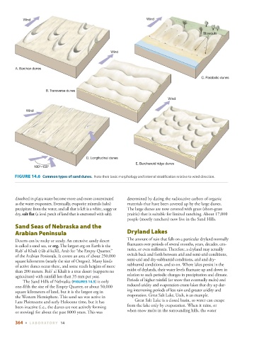
Wind                                                      Wind


                                                                                                 Blowouts


                                                     Wind


        A. Barchan dunes
                                                                                                C. Parabolic dunes


                       B. Transverse dunes

                                                                                Wind

             Wind


                                          D. Longitudinal dunes
                                                                 E. Barchanoid ridge dunes
                 100°–150°


          FIGURE 14.6    Common types of sand dunes.   Note their basic morphology and internal stratification relative to wind direction.


        dissolved in playa water become more and more concentrated   determined by dating the radioactive carbon of organic
        as the water evaporates. Eventually, evaporite minerals (salts)   materials that have been covered up by the large dunes.
        precipitate from the water, and all that is left is a white, soggy or   The large dunes are now covered with grass (short-grass
        dry,  salt flat  (a level patch of land that is encrusted with salt).          prairie) that is suitable for limited ranching. About 17,000
                                                             people (mostly ranchers) now live in the Sand Hills.
                Sand Seas of Nebraska and the
        Arabian Peninsula                                        Dryland Lakes
                                                               The amount of rain that falls on a particular dryland normally
          Deserts can be rocky or sandy. An extensive sandy desert
                                                             fluctuates over periods of several months, years, decades, cen-

        is called a sand sea, or  erg  . The largest erg on Earth is the
                                                             turies, or even millennia. Therefore, a dryland may actually
        Rub’ al Khali (rūb al ka’lē), Arab for “the Empty Quarter,”
                                                             switch back and forth between arid and semi-arid conditions,
        of the Arabian Peninsula. It covers an area of about 250,000
                                                             semi-arid and dry-subhumid conditions, arid and dry-
        square kilometers (nearly the size of Oregon). Many kinds
                                                             subhumid conditions, and so on. Where lakes persist in the
        of active dunes occur there, and some reach heights of more
                                                             midst of drylands, their water levels fluctuate up and down in
        than 200 meters. Rub’ al Khali is a true desert (supports no
                                                             relation to such periodic changes in precipitation and climate.
        agriculture) with rainfall less than 35 mm per year.
                                                             Periods of higher rainfall (or snow that eventually melts) and
              The Sand Hills of Nebraska (  FIGURES  14.5         ) is only

                                                             reduced aridity and evaporation create lakes that dry up dur-
        one-fifth the size of the Empty Quarter, or about 50,000
                                                             ing intervening periods of less rain and greater aridity and
        square kilometers of land, but it is the largest erg in
                                                             evaporation. Great Salt Lake, Utah, is an example.
        the Western Hemisphere. This sand sea was active in
                                                                   Great Salt Lake is a closed basin, so water can escape
        Late Pleistocene and early Holocene time, but it has
                                                             from the lake only by evaporation. When it rains, or
        been inactive (i.e., the dunes are not actively forming
                                                             when snow melts in the surrounding hills, the water
        or moving) for about the past 8000 years. This was
        364  ■  L ABOR ATORY  14