
Page 434 - Laboratory Manual in Physical Geology
P. 434
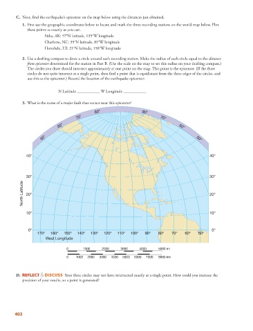
C.   Next, find the earthquake’s epicenter on the map below using the distances just obtained.


                1.   First use the geographic coordinates below to locate and mark the three recording stations on the world map below. Plot
              these points as exactly as you can.
                         Sitka, AK: 57°N latitude, 135°W longitude
                       Charlotte, NC: 35°N latitude, 81°W longitude
                       Honolulu, HI: 21°N latitude, 158°W longitude

               2.   Use a drafting compass to draw a circle around each recording station. Make the radius of each circle equal to the  distance

              from epicenter  determined for the station in Part B. (Use the scale on the map to set this radius on your drafting compass.)
              The circles you draw should intersect approximately at one point on the map. This point is the epicenter. (If the three
              circles do not quite intersect at a single point, then find a point that is equidistant from the three edges of the circles, and
              use this as the epicenter.) Record the location of the earthquake epicenter:


                             N Latitude ___________ W Longitude ___________


               3.   What is the name of a major fault that occurs near this epicenter?

                                               80°                    80°
                                      70°                                     70°
                             60°                                                       60°


                     50°                                                                        50°


              40°                                                                                     40°


              30°                                                                                     30°
            North Latitude  20°                                                                       20°


              10°                                                                                     10°


               0°                                                                                      0°
                   170°  160°   150°  140°   130°  120°   110°  100°   90°   80°    70°   60°    50°
                       West Longitude


                                 0       1000     2000     3000     4000      5000 mi
                                 0    1000  2000  3000  4000  5000  6000  7000  8000 km


           D.      REFLECT & DISCUSS  Your three circles may not have intersected exactly at a single point. How could you increase the
            precision of your results, so a point is generated?


        402