
Page 435 - Laboratory Manual in Physical Geology
P. 435
A CTIVIT Y 16.4 San Andreas Fault Analysis at Wallace Creek
Name: ______________________________________ Course/Section: ______________________ Date: ___________
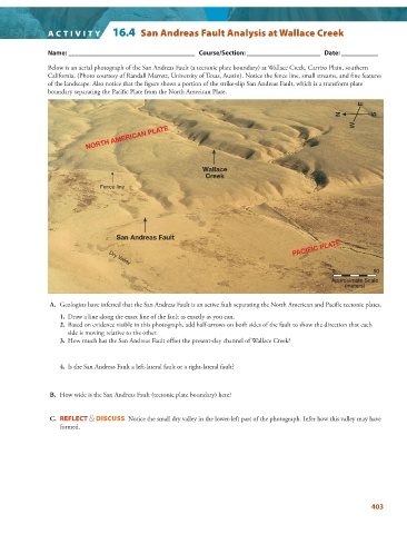
Below is an aerial photograph of the San Andreas Fault (a tectonic plate boundary) at Wallace Creek, Carrizo Plain, southern
California. (Photo courtesy of Randall Marrett, University of Texas, Austin). Notice the fence line, small streams, and fi ne features
of the landscape. Also notice that the figure shows a portion of the strike-slip San Andreas Fault, which is a transform plate
boundary separating the Pacific Plate from the North American Plate.
E
N S
W
NORTH AMERICAN PLATE
Wallace
Creek
Fence line
San Andreas Fault
PACIFIC PLATE
Dry Valley
0 50
Approximate Scale
(meters)
A. Geologists have inferred that the San Andreas Fault is an active fault separating the North American and Pacific tectonic plates.
1. Draw a line along the exact line of the fault as exactly as you can.
2. Based on evidence visible in this photograph, add half-arrows on both sides of the fault to show the direction that each
side is moving relative to the other.
3. How much has the San Andreas Fault offset the present-day channel of Wallace Creek?
4. Is the San Andreas Fault a left-lateral fault or a right-lateral fault?
B. How wide is the San Andreas Fault (tectonic plate boundary) here?
C. REFLECT & DISCUSS Notice the small dry valley in the lower-left part of the photograph. Infer how this valley may have
formed.
403