
Page 436 - Laboratory Manual in Physical Geology
P. 436
A CTIVIT Y 16.5 New Madrid Blind Fault Zone
Name: ______________________________________ Course/Section: ______________________ Date: ___________
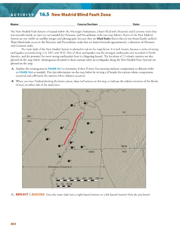
The New Madrid Fault System is located within the Mississippi Embayment , a basin filled with Mesozoic and Cenozoic rocks that
rest unconformably on (and are surrounded by) Paleozoic and Precambrian rocks (see map below). Faults of the New Madrid
System are not visible on satellite images and photographs, because they are blind faults (faults that do not break Earth’s surface).
These blind faults occur in the Paleozoic and Precambrian rocks that are buried beneath approximately a kilometer of Mesozoic
and Cenozoic rocks.
The main fault of the New Madrid System is plotted in red on the map below. It is well known, because a series of strong
earthquakes occurred along it in 1811 and 1812. One of these earthquakes was the strongest earthquake ever recorded in North
America, and the potential for more strong earthquakes here is a lingering hazard. The locations of 13 seismic stations are also
plotted on the map below. Seismograms obtained at these stations (after an earthquake along the New Madrid Fault System) are
plotted on the map.
A. Analyze the seismograms in FIGURE 16.7 to determine if their P-wave first motions indicate compression or dilation (refer
to FIGURE 16.6 as needed). Plot this information on the map below by writing a C beside the stations where compression
occurred and a D beside the stations where dilation occurred.
B. When you have finished plotting the letters above, draw half-arrows on the map to indicate the relative motions of the blocks
of rock on either side of the main fault.
ILL
8
10
KY
MO
ARK
7
4
5
9
3
6
12
2 11 TENN
MISS ALA
13
1
Mississippi Embayment
0 40 80 120 160 200 240 km
0 20 40 Mi
C. REFLECT & DISCUSS Does the main fault have a right-lateral motion or a left-lateral motion? How do you know?
404