
Page 56 - Laboratory Manual in Physical Geology
P. 56
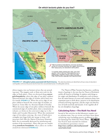
On which tectonic plate do you live?


                                 ALASKA


                                                            CANADA


                                                                   NORTH AMERICAN PLATE

                                 PACIFIC
                                 OCEAN
                                                                       Chicago
                                                                                        New York
                                                                   UNITED STATES
                           PACIFIC PLATE        Los Angeles
                                                Los Angeles
                                                Los Angeles
                                                                                               ATLANTIC
                                                                                                OCEAN
                                                                 MEXICO
                                                                                                          AFRICAN
                                                                                  CARIBBEAN                 PLATE
                                 Sacramento                                          PLATE
                                             North                   COCOS
                             San Francisco  American                  PLATE                    SOUTH
                                             Plate                                       AMERICAN PLATE
                                       Fresno
                                                             Plate boundaries (indicated by red lines) are linear
                                                             zones of movement between the plates, identified by
                                                             their topography and abundant earthquakes.

                      Pacific                                For greater detail, earthquake data, and other
                       Plate       Los Angeles               regions, refer to the U.S. Geological Survey‘s,
                                   Los Angeles
                                   Los Angeles
                                                             Earthquake Hazards Program real-time map:
                                                             http://earthquake.usgs.gov/earthquakes/map/
                                         San Diego
                                            Tijuana


                  FIGURE 2.1  Lithospheric plates associated with North America.   The plate boundaries are identified as linear zones of abundant


                earthquakes; whereas the plates tend to have few concentrated zones of earthquake activity.
               where magma rises up between plates that are spread-         The Theory of Plate Tectonics has become a unifying
               ing apart. The magma cools to form new rock on the   theory of geology in the way that the Theory of Evolution
               edges of both plates.  Plates are destroyed  along  conver-  unifies all elements of biology. It explains such things as
               gent boundaries  ,  where the edge of one plate  subducts    the origin and distribution of earthquakes and volcanoes,
               (descend beneath the edge of another plate) back into   how the main features of oceans and continents form, how


               the mantle (  FIGURE   2.2 ). When the ocean edge of one   continents seem to drift about, patterns in the distribution

               plate s ubducts beneath the ocean edge of another, an   of fossil and living organisms, and the origin and distribu-
               island arc forms (like the Aleutian Islands of Alaska).   tion of Earth materials and hazards. It ties together all of
               When the ocean edge of one plate subducts beneath the   the sub-disciplines of geology.
               continental edge of  another plate, then a mountainous
               volcanic arc forms on the  continent’s edge (as in the       Calculating Rates—The Math You Need
               Andes and Cascades  Mountains). When the continental     Several of the activities in this laboratory require you
               edges of two plates converge, the crust of both plates   to calculate rates. You can review and learn more about
               crumples into large folds and merge to form a tall     calculating rates (including practice problems) at this
               mountain belt (like the Alpine-Himalayan Mountain    site featuring The Math You Need, When
               Belt) that is eventually destroyed by weathering and   You Need It math tutorials for students
               erosion of the  mountains).  Plates slide past one another    in introductory geoscience courses:

               along  transform  boundaries , where plates are neither    http://serc.carleton.edu/mathyouneed/
               created nor destroyed (  FIGURE   2.2   ).           rates/index.html

                                                                                 Plate Tectonics and the Origin of Magma   ■  41