
Page 78 - Laboratory Manual in Physical Geology
P. 78
ACTIVITY 2.5 Atlantic Seafloor Spreading
Name: ______________________________________ Course/Section: ______________________ Date: ____________
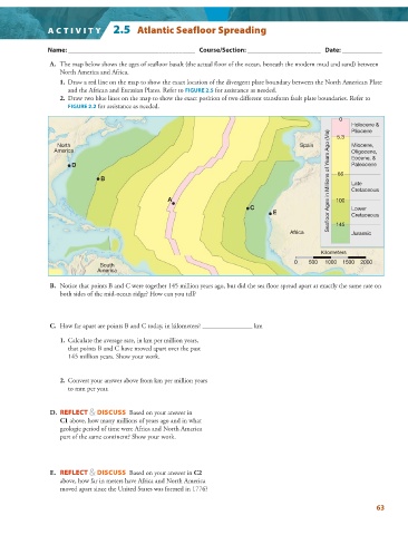
A. The map below shows the ages of seafloor basalt (the actual floor of the ocean, beneath the modern mud and sand) between
North America and Africa.
1. Draw a red line on the map to show the exact location of the divergent plate boundary between the North American Plate
and the African and Eurasian Plates. Refer to FIGURE 2.5 for assistance as needed.
2. Draw two blue lines on the map to show the exact position of two different transform fault plate boundaries. Refer to
FIGURE 2.2 for assistance as needed.
0
Holocene &
Pliocene
Seafloor Ages in Millions of Years Ago (Ma) Late
North Spain 5.3 Miocene,
America Oligocene,
D Eocene, &
Paleocene
B 66
A 100 Cretaceous
C Lower
E Cretaceous
Africa 145 Jurassic
Kilometers
0 500 1000 1500 2000
South
America
B. Notice that points B and C were together 145 million years ago, but did the sea floor spread apart at exactly the same rate on
both sides of the mid-ocean ridge? How can you tell?
C. How far apart are points B and C today, in kilometers? _______________ km
1. Calculate the average rate, in km per million years,
that points B and C have moved apart over the past
145 million years. Show your work.
2. Convert your answer above from km per million years
to mm per year.
D. REFLECT & DISCUSS Based on your answer in
C1 above, how many millions of years ago and in what
geologic period of time were Africa and North America
part of the same continent? Show your work.
E. REFLECT & DISCUSS Based on your answer in C2
above, how far in meters have Africa and North America
moved apart since the United States was formed in 1776?
63