
Page 79 - Laboratory Manual in Physical Geology
P. 79
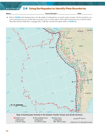
ACTIVITY          2.6  Using Earthquakes to Identify Plate Boundaries


          Name: ______________________________________   Course/Section: ______________________   Date: ____________

           A.     Refer to  FIGURE   2.2  for background on how the depth of earthquake foci is related to plate tectonics. On the map below, use


            a red colored pencil or pen to draw lines (as exactly as you can) that indicate where plate boundaries occur at Earth’s surface.
            Then label the East Pacific Rise, Galapagos Rise, Chile Rise, and all of the plates (refer to  FIGURE   2.5   ).


                        100°W               90°W                80°W
                                                                                                       Guyana
                                                                                           Venezuela


         110°W                                                                Columbia

         10°N

                                                                                             Brazil
                                                           Ecuador
                                                                              Peru


         0°

                                                                                                 Bolivia


                                                                                                         Para-
                                                                                                         guay
         10°S


                                                                                                           B´
                                                                                     B


         20°S                                                                                       Argentina


                                                                                   Chile


            0      500    1000 km

          30°S              120°W              40°S     100°W                      80°W

                                                    ▲   ▲   ▲   ▲   ▲   ▲   ▲   ▲   ▲   ▲   ▲   ▲   ▲   ▲   ▲   ▲   ▲   ▲   ▲   ▲   ▲   ▲   ▲   ▲   ▲   ▲   ▲   ▲   ▲   ▲   ▲   ▲   ▲   ▲   ▲   ▲   ▲   ▲   ▲   ▲   ▲   ▲   ▲   ▲   ▲   ▲   ▲   ▲   ▲   ▲   ▲   ▲   ▲   ▲   ▲   ▲   ▲   ▲   ▲
                    Map of Earthquake Activity in the Eastern Pacific Ocean and South America
                   Shallow-focus         Intermediate-focus    Deep-focus               ▲   ▲   ▲   ▲  Trench
                   earthquakes           earthquakes           earthquakes
                   0–69 km deep          70–299 km deep        300–700 km deep     (Data from U.S. Geological Survey)


        64