
Page 76 - Laboratory Manual in Physical Geology
P. 76
ACTIVITY 2.4 Paleomagnetic Stripes and Seafloor Spreading
Name: ______________________________________ Course/Section: ______________________ Date: ____________
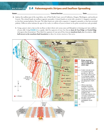
A. Analyze the seafloor part of the map below, just off the Pacific Coast, west of California, Oregon, Washington, and southwest
Canada. The colored bands are seafloor magnetic anomalies. Colored bands are rocks with a positive (+) magnetic anomaly,
so they have normal polarity, like now. The white bands are rocks with a negative (-) magnetic anomaly, so they have reversed
polarity. Different colors indicate the ages of the rocks, in millions of years as shown in the polar reversal time scale provided.
1. Using a pencil, draw a line on the sea floor to show where new ocean crust and lithosphere is forming now (zero millions
of years old). Using FIGURE 2.2 as a guide, label the segments of your line that are Juan de Fuca Ridge and Gorda Ridge
(divergent plate boundaries). Then label the segments of your pencil line that are transform fault plate boundaries. Add
half-arrows to the transform fault boundaries to show the relative motion of the rocks.
0 50 100 200 300 400 miles
Silverthrone
Caldera
Franklin 0 50 100 500 kilometers
Glacier Volcano
Mount Meager
Mount Cayley
Mount Garibaldi
CANADA
A Mt. Baker WASHINGTON MONTANA
C A S C A D E R A N G E of normal magnetic
B Glacier 0 Polar reversal
Peak
C time scale: ages
are in millions of
years ago
D
Mount St. Mt. Rainier 2 Colors indicate rocks
Helens Mt. Adams
polarity (+), like now.
of a compass needle
Crest of Mt. Hood 4 The north-seeking end
Juan de Fuca Mt. Jefferson would have pointed in
Ridge the general direction of
N Three Sisters 6 the geographic North
Pole.
Newberry
Volcano White areas have
W E reversed magnetic
Crater Lake
polarity (–). At those
S OREGON 8 times, the north and
south poles exchanged
positions. The
Mount Medicine north-seeking end of a
= volcano Shasta Lake Volcano compass would have
pointed in the general
Lassen Peak
11 direction of the
CALIFORNIA geographic South
Pole.
Crest of
Gorda 12
Ridge
Seafloor Seafloor
spreading spreading
west east
Magma
61