
Page 81 - Laboratory Manual in Physical Geology
P. 81
A CTIVIT Y 2.7 San Andreas Transform-Boundary Plate Motions
Name: ______________________________________ Course/Section: ______________________ Date: ____________
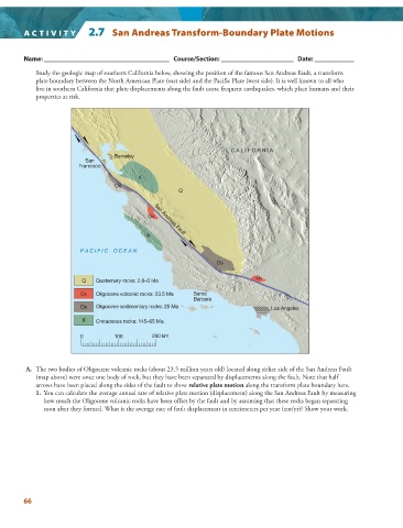
Study the geologic map of southern California below, showing the position of the famous San Andreas Fault, a transform
plate boundary between the North American Plate (east side) and the Pacific Plate (west side). It is well known to all who
live in southern California that plate displacements along the fault cause frequent earthquakes, which place humans and their
properties at risk.
C A L I F O R N I A
Berkeley
San
Francisco
K
Os
Q
Ov San Andreas Fault
K
P A C I F I C O C E A N
Os
Ov
Q Quaternary rocks: 2.6–0 Ma
Ov Oligocene volcanic rocks: 23.5 Ma Santa
Barbara
Os Oligocene sedimentary rocks: 25 Ma Los Angeles
K Cretaceous rocks: 145–65 Ma
0 100 200 km
A. The two bodies of Oligocene volcanic rocks (about 23.5 million years old) located along either side of the San Andreas Fault
(map above) were once one body of rock, but they have been separated by displacements along the fault. Note that half
arrows have been placed along the sides of the fault to show relative plate motion along the transform plate boundary here.
1. You can calculate the average annual rate of relative plate motion (displacement) along the San Andreas Fault by measuring
how much the Oligocene volcanic rocks have been offset by the fault and by assuming that these rocks began separating
soon after they formed. What is the average rate of fault displacement in centimeters per year (cm/yr)? Show your work.
66