
Page 109 - Modern Spatiotemporal Geostatistics
P. 109
—
Chapter
4
Geostatistics
Modern
90 90 Modern Spatiotemporal Geostatistics — Chapter 4
Spatiotemporal
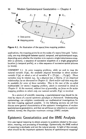
Figure 4.1. An illustration of the space/time mapping problem.
applications, the mapping points lie on the nodes of a space/time grid. Techni-
cally, one may distinguish between spatial, temporal, and spatiotemporal maps,
depending upon whether the intention is to capture a single instantaneous snap-
shot (a picture), a sequence of successive snapshots at a single geographical
location (a temporal profile), or a video sequence of successive spatial pictures
(a movie).
COMMENT 4.1 : I n some mapping problems, while w e seek t o ma p th e
natural variable X(p), the available physical knowledge is about another
variable Y(p) o r about a set o f variables Y = (Yi(p),... , Y)v(p)) . These
variables ma y b e related, e.g. , b y a physical law, a theory, o r a n empirical
relationship (as we discussed in Chapter 3). Hard and/or soft data may also
be available for some of these variables. This is the case of the so-called
multivariable (o r vector,) mapping problem, which is examined i n detail i n
Chapter 9 . A t th e moment, without loss of generality, we focus on the scalar
mapping problem in which only one natural variable X(p) is involved.
As a product of scientific reasoning, a spatiotemporal map should be de-
rived by means of a sound epistemic paradigm or framework. Understanding
epistemology can enlighten considerably our mathematical investigations for
the best mapping approach possible. In the following sections we will first
discuss some general characteristics of the epistemic investigations of modern
spatiotemporal geostatistics, and then we will focus our attention to a particular
method, namely, the Bayesian maximum entropy (BME) analysis.
Epistemic Geostatistics and the BME Analysis
One uses logical reasoning to obtain answers to questions related to the acqui-
sition, meaning, and processing of knowledge. Epistemically, the BME method
of reasoning is stochastic and not the natural process. In light of this concept,
what should be the important epistemic features of spatiotemporal mapping?