
Page 55 - Modern Spatiotemporal Geostatistics
P. 55
36 Modern Spatiotemporal Geostatistics — Chapter 2
DEFINITION 2.2: In the rectangular Euclidean coordinate system, s =
(si,..., s n) and t are the orthogonal projections of a geometrical point P t
on the spatial axes and the temporal axis, respectively; i.e., the following
mapping is defined
Alternatively, starting from the spatial coordinates s,, £ S and the time
instant tj € T, a geometrical point P^ can be defined in Euclidean
space/time as
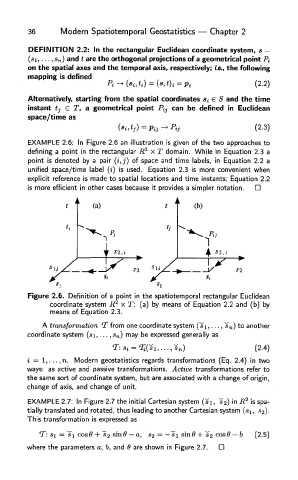
EXAMPLE 2.6: In Figure 2.6 an illustration is given of the two approaches to
defining a point in the rectangular R 2 x T domain. While in Equation 2.3 a
point is denoted by a pair (i, j) of space and time labels, in Equation 2.2 a
unified space/time label (i) is used. Equation 2.3 is more convenient when
explicit reference is made to spatial locations and time instants; Equation 2.2
is more efficient in other cases because it provides a simpler notation.
Figure 2.6. Definition of a point in the spatiotemporal rectangular Euclidean
coordinate system R 2 x T: (a) by means of Equation 2.2 and (b) by
means of Equation 2.3.
A transformation T from one coordinate system (s\,..., *s n) to another
coordinate system (si,...,s n) may be expressed generally as
i = 1, ...,n. Modern geostatistics regards transformations (Eq. 2.4) in two
ways: as active and passive transformations. Active transformations refer to
the same sort of coordinate system, but are associated with a change of origin,
change of axis, and change of unit.
2
EXAMPLE 2.7: In Figure 2.7 the initial Cartesian system (si, s^) in R is spa-
tially translated and rotated, thus leading to another Cartesian system (si, sg).
This transformation is expressed as
where the parameters a, b, and 6 are shown in Figure 2.7.